Maptech's Outdoor
Navigator Iraq SD Card
Very Detailed Street-level
Maps for Palm Powered Handhelds
Reviewed with the Garmin
iQue 3600
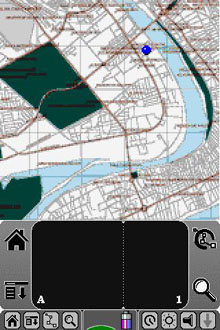
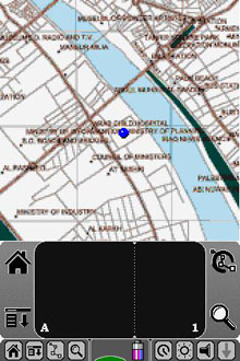
iQue Screen Shots
Provided by LinkeSOFT
(10 Mar. 2005) Text by Jack
Yeazel
Return
to GPS General Information Home Page
INSTALLATION:
This SD card is truly "plug and play". Just insert the SD
card into the card slot. As soon as the card is inserted, the handhelds
screen will show the program icon and program name. The program name,
OutdoorNavSD, may be clipped depending on how your handheld is configured,
but the icon will be the only one present. Tap the icon to start
Outdoor Navigator, Iraq.
Detailed maps are provided for these areas: Amarah, Kut, Sulaymaniya,
Baghdad, Basra, Diwaniyah, Irbil, Karbala, Kirkut, Mosul, Najaf, and Tikrit.
Less detailed maps are provided for: Amarah, Qa'im, Rutbah, Gharbi, Salman,
Baramadad, Najaf, Fallujah, Ghalaysan, Khanaqin, Khrsiu, Khurmal, Nazdur,
Qayyarah, Samana, Sinuar, Salman, and Turaybil.
OVERVIEW:
The SD card is available (HERE)
for $300. This version of Outdoor Navigator is only compatible with
Palm Powered
devices, including the Garmin iQue which has a built-in GPS. There
are also GPS add-ons for most handhelds including Bluetooth GPS antennas
that transmit your position wirelessly to your handheld.
The GPS software lets you quickly view maps, lat/long coordinates
and more. Connect a GPS (or use the Garmin iQue's built-in GPS), and you'll
see your position right on the map. If you move, your position on the map
moves. Data boxes can be configured to display key navigation information
including speed, direction and lat/long position.
OPERATION:
Outdoor Navigator has re-assigned certain iQue keys. (From
left to right) the "Date Book" key brings up the Data Boxes at the bottom
of the map. Pressing on each box will show: AVE
SOG, COG, GPS POS, WPT RNG, WPT BRG, WPT TTG, PEN RNG, PEN BRG, PEN POS,
RTE XTE, RTE DTG, RTE TTG, or SOG. The PEN
boxes refer to where the stylus is placed on the map, and the WPT
boxes
refer to the Active waypoint.
Next, the "Address" key will select a less-detailed map (if there
is one), the "To Do" key will select a more-detailed map (if there is one),
and the "Map" key activates the Follow Mode (causes the map to pan as you
go along). If there is a red circle around the black present-position
icon, the unit is not in the Follow Mode. If the icon is outlined
in red, satellite reception is lost. The "Up and Down" key zooms
the map as usual. After panning, pressing and holding the Follow
button causes the position icon to stay fixed on the map. This is
useful if traveling long distances in the same direction. One can
also pan the map by double-clicking on it.
The lower icon to the left of the scratch pad is the main Outdoor
Navigator drop-down menu. This menu accesses: Options, GPS, and Help.
From Options: Maps, Marks (waypoints), Routes, and Preferences are accessed.
Dragging the stylus across the map causes it to pan. (Then the Follow
Mode must be activated to resume automatic pan).
Waypoints are created by pressing the stylus on the map. This
waypoint can be made either Active and/or Locked. If Active, then
a blue bearing line from present position to the Active waypoint is shown.
If not Locked, then the waypoint can be moved around the map with the stylus.
Routes are created by marking the first point and classifying it
as a New Route. Continue to Add Waypoint Here at the various route
points. At the last point, select Add Waypoint and Save Route.
From the Routes menu, select the route name and Edit it. Two options
are to Activate the route and/or Lock the waypoints. Activating the
route will also activate the RTE
data boxes. The route lines are in red (whether activated or not),
and a blue bearing pointer always points to the next waypoint.
THE MAPS:
Until now, there were very limited GPS maps to offer our troops
being assigned to Iraq, the most common being Garmin's WorldMap.
After coming across the Maptech maps, we purchased a Garmin iQue 3600 to
provide a platform for evaluating them. The iQue has a relatively
short battery life and should be considered mainly as a vehicle installation.
A "car kit" provides an installation bracket and cigarette-lighter cable
for charging the battery and operating the unit.
The map data was provided by LeadDog consulting. LeadDog has
GIS maps of Iraq that are used in professional applications like ESRI's
ArcGIS. Maptech turned the map data into maps compatible with Outdoor
Navigator.
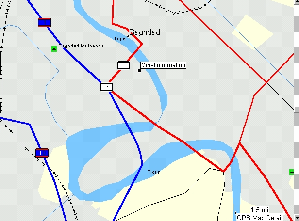
Garmin WorldMap and Approximate Location
of the Ministry of Information
 .....
..... .....
.....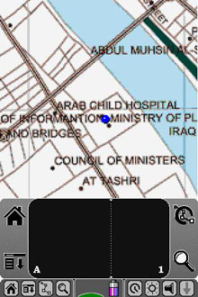
Maptech 1:25,000 Baghdad Map (Shows
a Waypoint at the Ministry of Information)
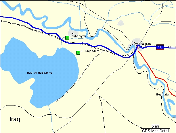
Garmin WorldMap of Fallujah
.jpg) ..
...jpg) ..
...jpg) ..
...jpg)
Maptech's collection also contains
1:250,000 Maps, Shown Here of Fallujah
COMPATIBILITY:
Palm - any device with these: Palm OS v4.0 or later, Color screen,
Memory card slot.
CONS:
The program doesn't allow hiding the scratch pad nor show tracks.
Although one can create waypoints by pressing and holding the stylus on
the Outdoor maps, they can't be uploaded from a database.
Future Developments:
We talked with Maptech, and there are some new developments coming
for the standard Outdoor
Navigator program, but not the SD version. These include
the ability for Outdoor Navigator to read Maptech's CD maps and charts.
Once released, the recommended offering for Iraq will be: 1) Outdoor Navigator
software for $19.95 and 2) Terrain Pro, Iraq CD for $299.95.
This will put Iraq maps on Windows Mobile Smartphones and Pocket PCs as
well as Palms. It will also allow free software upgrades as new features
like tracks are included.
CONCLUSION:
One of the best affordable GPS maps of Iraq -where not getting lost
is a matter of life or death. A solid moving map display software
for Iraq, easy to install and use, but limited in expandability and interaction
with other data sets.