Garmin's GPS 76C(S)(x)
Color
Mapping GPS Receiver with AUTOMATIC Routing
For specific questions about this product, log onto the GPSInformation.net
FORUM
Review by jack
yeazel,
joe
mehaffey, ron
henderson, and jack rajczewski
(27 Feb. 2006
-Add GPSmap 76Cx)
Return
to GPS Information Home Page
 .........
 ........
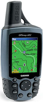
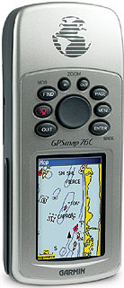
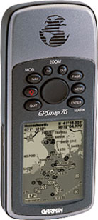
The GPSmap 76C(x) is a combination of the
GPSmap
76 case (center) and the GPSmap
60C color screen and auto routing.
OVERVIEW:
The Garmin 76C (about $415, the 76CS about $450, and the 76Cx about
$285), check latest prices (HERE),
are considered Marine units. The 76C is essentially identical to
the 60C, but the physical layout is different, and has over twice the map
memory for street price of only $35 more. For example, the 76 memory
is 8 MB, the 60C is 56 MB, the 76C is 115 MB, and the 76Cx comes with 128MB
of microSD memory. The 76 series contains tide information while
the 60 series doesn't. Maps are not included. Garmin suggests
the CitySelect maps (about $120) in order to use the auto-routing feature.
The 60 color and 76 color units also have the new USB capability
for uploading large maps. The units are the same size as the Garmin
GPSmap 76(S) but with a slightly smaller display (1.5" W x 2.2" H, vs the
76's 1.6" W x 2.2"H). The display size is exactly the same as that
in the 60C.
The color models have sunlight-readable display with 256-color transreflective
TFT display. Outside in even cloudy weather, we found the display
quite bright and readable without the backlight. This results from
Garmin's new hardware technology which offers a long battery life.
The screen backlight can be made quite bright. Probably among the
brightest we have seen. Running the backlight frequently or for long
durations will dramatically reduce battery life by a factor of about 2
1/2.
Garmin's claims 30 hours on just two AA alkaline cells, which seems
to be about right for intermittent use without a backlight. The normal
battery drain is a very low 62 ma, and with the backlight full, it is 160
ma. Pressing and holding the Page button on the 76CS units quickly
activates or deactivates the electronic compass, allowing a conservation
of
battery power.
NOTES: Firmware versions
can be seen by holding ENTER while turning the unit ON. This also
gives the diagnostics page. Press PAGE multiple times brings up additional
diagnostic screens. Comments on the 76C and 76CS are based on comparisons
of Garmin web site information, including a comparison of the manuals for
the two units.
FEATURES:
This class of units all have a similar set of features. They
all can create routes from waypoints, record tracks, calculate areas, track
back, and Autoroute. From the Menu, Menu, button: Proximity warning,
Calendar with good fishing times, Calculator, Stopwatch, Sun and Moon,
Hunt and Fish, Games, Trip Computer, Highway (3-D) map page, Page selections,
Personalized Splash screen, and Battery Save mode, but only the 76C has
an Alarm Clock. From the Find button: Tides (from the Marine icon),
and POIs of all kinds. The color units change to nighttime colors
at sundown, if desired.
AUTO-ROUTING:
Apparently all the new color units will also do autorouting and
have more user screen options than any unit that we have reviewed.
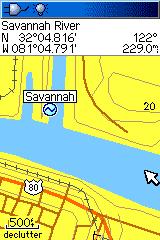
See sample screens (HERE).
A nice addition to the 76C(x) is control of just WHICH of the many screens
are actually displayed. This is accessed through Menu, Menu, Page
Seq. With automatic routing, users can input the address or waypoint
of a destination and the GPS-76C will compute a route and give turn-by-turn
instructions as the route is navigated. The GPS provides a moving
cursor on the moving map showing your position on the GPSR's internal map.
As a turn approaches, the map switches to a track-up display to aid in
the visualization of the needed turn. Two warnings are sounded prior
to the turn.
Automatic Route Generation:
The GPSmap 76C has the ability to generate an AUTOMATIC route from
your current location to another point. The destination point can
be any of: an address, waypoint, road intersection, city or
town, highway exit, Point of Interest from the internal list,
or Recently Found Places, and with the 'X'
models, Custom POIs. This extremely flexible system is easy to operate
and works quite well. We see generally high quality routes
generated with some that are "adequate" but not the ones we would have
chosen, but the performance we see is on a par with the best current
model auto navigators we have tested.
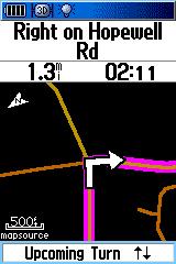
In an Auto-route situation, a new features in the 76C include a "pop
up" direction screen showing a blown up picture of the coming intersection
with an arrow pointing the way to turn and a couple of BEEPS at different
distances from the intersection to warn you of the upcoming turn.
Settings:
* If you set your vehicle type to Truck, the algorithm has a much
stronger tendency to route over freeways and will not make over 90°
turns.
* If you set your vehicle type to Bicycle, the device will route
you along the very shortest route, even using the smallest
residential streets. Also the ETA and ETE times are initially
bicycle speeds unless you speed up.
* The Car/Motorcycle setting avoids those and routes over the next
bigger road size where possible.
Manual Route Generation:
Garmin supplied this solution: Put the unit in simulator mode
and then on that same satellite page press the menu button again and scroll
down to new location and press enter. Then choose the option of use map
and press enter on it. The next thing you will do is to move the pointer
on the screen with your rocker pad to where you want the unit to think
is your current location or starting point. Then press the find button
on your unit and enter the destination you wish to route to. The
unit will create a route from that starting point to the destination you
set it to. One can then use Automatic Route Recalculation ON or OFF
to get the desired routing instructions.
It is also possible to manually generate a route by going to the
route page and panning the pointer and setting a series of waypoints along
your intended route. Routes can also be generated from within
MapSource and uploaded to the unit.
How Does the User Input a Route Request
to the GPSmap 76C?
It is pretty easy, but pictures help, click (HERE).
Note: In addition to Addresses, you
can route to POI, Intersections, Waypoints, Cities, Expressway
Exits and Recently found places.
NOTE: Vias are not currently supported in the conventional sense.
However since the 76C series is intended as an outdoor unit that also auto
routes. When you create a route by defining the destination, and
then auto routing to it, a simple method of inserting the via point is
not available.
Detours:
However, a check of the North America CityNavigator routing indicates
that the Freeways are permanently avoided with 'Avoid Highways'.
Don't forget to disable the Avoid Highways function again afterwards by
removing that check mark, otherwise you'll be routed off the freeway again
every time you calculate or recalculate a route. Incidentally, the
term Avoid Highways is incorrect, in that the unit doesn't 'Avoid Highways';
it avoids Freeways.
GPSmap 76C(S)x:
Briefly: 90% of the 76Cx
is the same as the 76C. The only things different with the 76Cx are
the processors, added custom POIs, no DGPS, USB can now power the unit,
microSD memory, lower case letters, and lack of an Alarm Clock.
The visual appearance is the same as the 76C, except that the screen
is noticeably sharper. And "X"
stands for a TransFlash (microSD) memory card for the uploadable maps.
The unit comes with a 128MB card, but we purchased a 512MB card and loaded
it up with as much map as possible to see what effect a large amount of
map storage would have on the map re-draw time, apparently not any.
The 60 and 76 series "X" models
ALSO contain the new SiRF star III GPS receiver processors, described (HERE)
and (HERE).
The power consumption is apparently within the limits of the USB standard,
since a USB connection will power the 76C(S)x units (but not the 76C(S)
units which draw less power). The 76Cx ran for 16 hours with 1600mah
NiMH batteries in the Normal mode and draws 100ma. Half backlight
requires 160ma and full backlight requires 200ma. Check battery drain
for other models (HERE).
The 'x'
models appear to support the "ANSI character set" which is an extended
character set that allows characters with accent marks (or "diacritics")
and some 'symbols' in addition to the standard ASCII character set.
The length of the waypoint name can be up to 14 characters and the length
of the comment can be up to 30 characters.
76C(S)x Custom POIs:
With Garmin's POI
Loader, you can add personal Points of Interest, such as setting
alarms for speed traps, 'Red Light Camera' locations, etc. Speeds
can be associated with individual custom POIs, and they don't take away
from waypoint memory. NOTE: Apparently the only way to 'delete' Custom
POIs is to rewrite them. A menu command has not been found which
will allow the user to delete Custom POIs.
UNIT SENSITIVITY
AND ACCURACY:
 .....
.....
Screen Shots of the 76C and the 76Cx
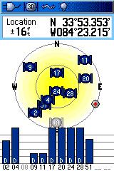
inside a House Room
Note that the 76C is searching for WAAS Sats ° The 76Cx
has locked onto #51 and has deiiferenial corrections
The following three plots are with the 76Cx's original Chipset Type
G software and unit firmware.
The last two plots are with version 2.60 of the Chipset Type G software
(which updated the WAAS almanacs) and unit Firnware 2.90.
NOTE: The 76Cx, 76CSx and 60CSx and 60Cx units
were initially released with "less than ideal" chipset firmware.
This firmware caused greater than expected position errors when the GPSs
were receiving WAAS corrections. An update was released June 29th
2006 that addressed the problems. The tests below are indicative
of the results with "x" units after applying the chip set upgrade.
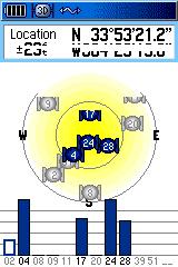
SA Watch Plots Under Moderate Tree Cover
(The reference point here is only known to about 1m, and therefore
the WAAS Spec of 3m is not expected)
GPSmap 76Cx with New Chip
Software and Unit Firmware
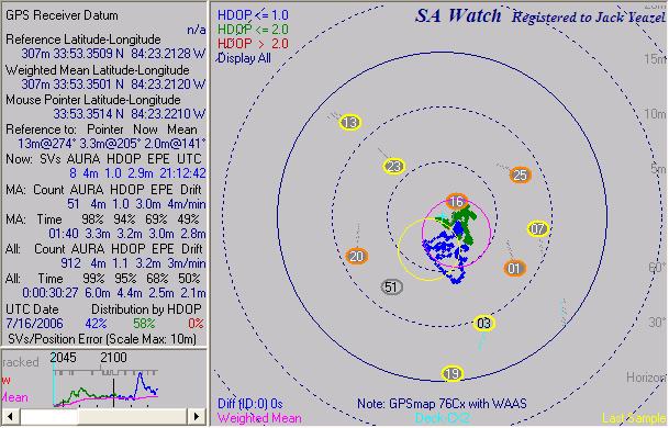
GPSmap 76Cx Summary: 95% of errors
are 4.4m or less, average error is 2.0m, and drift is 3m/min
Note: The unit is now receiving WAAS Sat #51.
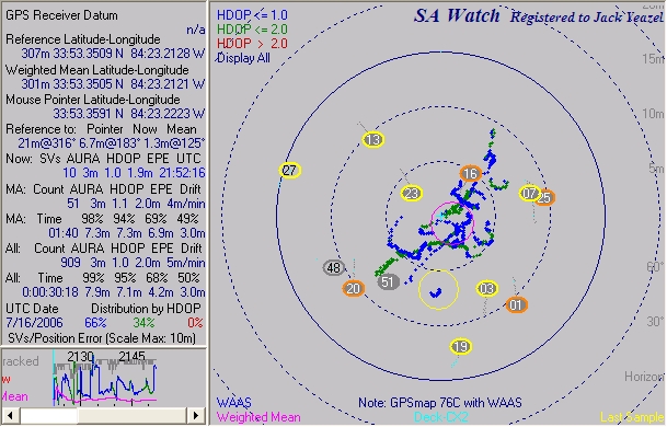
GPSmap 76C Summary: 95% of errors
are 7.1 m or less, average error is 1.3m, and drift is 5m/min
Note: The unit is receiving both WAAS Sats #51 and #48.
Thus the new software and firmware for the GPSmap 76Cx has improved
its accuracy (under tree cover) from about 10m to 4.4m 95% of the time.
The GPSmap 76C accuracy remained in the neighborhood of 7m.
Comparative Accuracy:
Using a moderate tree-cover test site, we ran 30-minute test runs
with SA
Watch comparing the GPSmap 76C to the Magellan SporTrak Color
(HERE).
The 76C seemed quite "erratic". 95% of the 76C errors were
9.7 meters or less, where the SporTrak Color were less than 1.6 meters.
"S" IS FOR SENSORS:
The GPSmap 76 and 60 series also include the 76S, 76CS(x), and 60CS(x)
which have an added electronic compass and barometer. We don't have
a 76CS(x) or 60CS(x) to review, but those sensors were evaluated
in our GPSmap
76S review. It's assumed that these sensors work like
the sensors in the 76S.
MAPPING SOFTWARE:
The base maps on the 76C and 60C are different, The 60C has
recreation and the 76C has the same base map as the expensive auto units,
street pilots, per Garmin site. A subtle difference but it's
a better map, bottom line. Some prefer the screen on top as in the
60C, but the extra memory will be more important, we believe.
The 76C DOES NOT come with any street-level or automatic routing
software in the standard package. Instead, it comes with a POI CD
and software which allows upload and download of waypoints, routes and
tracks. It is designed to work with "CitySelect 6/7" (NavTech-based
maps), but it will also auto-route with CityNavigator and MetroGuide-4
maps.
The user can up/download routes and waypoints to the PC MapSource
program. CitySelect software is similar to "CityNavigator" software
furnished with the StreetPilot 2610 units. Garmin recommends CitySelect
for the GPSmap 76C and the CityNavigator for the GPSmap 76Cx. A user
can install ALL (or just some) USA regions and available Canada maps into
a PC computer. Then the user selects which map subsections to load
to fill all or part of the 76C's 115 megabytes of internal map memory,
or the 76Cx's microSD memory.
NOTES:
1. The Mexico
Maps' GPS maps require a previous purchase of a Garmin map or
a copy of Garmin's MapSource Trip & Waypoint Manager in order to have
the ability to upload these maps to Garmin units.
2. With these maps, you have a map that can also be displayed on
MapSource (along with your GPS data) -unlike the Garmin Mexico NT maps,
which cannot be shown on a PC screen.
USING TracBack:
First record a track (turn Track Log, ON). You should then
'Save' it for future reference, or you can use the detailed track to track
back along. From the Tracks menu, select either the current recorded
track or a saved track, and then press TracBack. The screen that
comes up is going to ask you which point on the track you want to TracBack
to. You can select this point with the cursor. (Each track
will also have a BEGIN or END waypoint you can select). Note that
saved tracks lose their time stamps and compress to no more than 500 trackpoints.
In a Tracback situation, the "Highway" page is useful for marine
or street-level tracking. A Compass page is also available where
the pointer can be changed from a Bearing to a Course pointer. "Bearing"
is the direct direction to the next routepoint from present position and
is useful for hiking. The Course pointer calculates a fixed line
from present position or a routepoint to the next routepoint and us useful
for marine navigating. The "To Course" command directs one immediately
back to the course line. NOTE that the Course pointer is not the
direction to the next waypoint but remains fixed on a course line.
It functions like an aircraft CDI (Course Deviation Indicator) and also
has a TO/FROM flag.
TIDES:
From the FIND button, select the
Marine icon


Tides Station - Select
nearer Tide Stations - Tide graph at 9:16am - Map
display (topo map)
Pressing and holding the Find button activates a Man Overboard
(MOB) feature where the location is instantly marked and the navigation
feature is immediately activated. This enables one to go back to
the marked location with a minimum of button-pushing effort while under
stress of the moment. Proximity and Anchor Drag waypoints are also
supported with the beep alarm.
LOGGING:
Waypoints: 1000 with name and
graphic symbol, automatic display of 10 nearest and with 10 proximity
waypoints. The closest 50 waypoints can be listed.
Tracklogs: The tracklog
capacity is 10,000 trackpoints with 20 saved compressed tracks with 500
points each which allows a user to retrace their steps with TrackBack.
Routes: 50 reversible routes
with an unknown number of points in each route.
Tracklog resolution can be set to Auto, Time or Distance. With
WAAS, this unit is well suited for placing or recovery of Geocached objects.
It has no trouble, with a few minutes averaging in the clear, to
establish a reference point within 3 meters. The unit also contains
a MOB (Man Over Board) mode.
GEOCACHE:
The manual isn't as clear as it could be for finding caches.
For optimum use (and to call up the compass page, as the manual shows)
if one in: Setup, Routing, sets Guidance Method and Follow Road Method
to "Prompted", then when accessing a Geocache waypoint, you can select
Off Road, and the compass page will appear. Also the waypoint selected
must be a geocache waypoint.
SOFTWARE COMPATIBILITY: As with
many other Garmin models,
G7ToWin Version A.00.200e has been updated to support up/downloading
of waypoints, tracks, and routes to the Garmin 76C(x), through both the
USB and Serial cables. The following programs are known only to be compatible
with the 76C's serial connection**
**Please advise if these facts have been changed!
EasyGPS and ExpertGPS
will support all Garmin USB receivers in their next releases.
Fugawi -supports Garmin's USB
enabled units.
GARtrip is compatible with
the serial cable, and USB will follow with a future program release.
GPS Utility
provides Ver. 4.15.3 (available from the download page) which supports
the GPSmap 76 over the USB interface.
Street Atlas 4 thru 9 can upload waypoints and routes, download
tracks, but cannot download waypoints or routes from the unit. It's not
known if Street Street Atlas 2004 can calculate routes, create waypoints,
and upload these to the 76C.
Ozi Explorer
is compatible for up/download waypoints, tracks, and routes to the Garmin
76C via serial or USB.
TTQV (TouraTech) is compatible
with serial and USB. Perfect for the european market with its ability
to read most (if not all) CD ROM based map products, and is able to overlay
the european Navteq maps onto a Topo map.
USAPhotoMaps
can transfer waypoints, tracks, and position, but not routes via serial
or USB.
Complete Reset:
Press "Enter, Page, and Power on keys" to get to the message that
says, "Do you really want to erase all user data". Before you say
"YES", I would strongly recommend you download your waypoints, tracks,
and routes to a computer, and write down your settings as they will all
be erased or reset. Of course your software version will remain the same,
and any downloaded maps will still be there.
And then: From the Trip Computer Page, while there push the scroll
key up, right, down, & then left to get to a diagnostic screen used
by Garmin Techs. I would not recommend playing with this screen too
much, less you want to ship your unit back to Garmin for repair!
What is our Overall Opinion of the GPSmap
76C(x)?
These units are a superior product overall. They provide a
complete Car Navigator feature and Hiking GPS features as well as a useful
set of Marine navigation features. While it is not as inexpensive as the
GPS-V and some other competitors, we think the color screen is about
the best we have seen for out-in-the-sunshine use. The GPSmap 76CS(x)
is essentially the same instrument as the 76C(x) but with a barometer and
electronic compass added. We have not tested this configuration.
What do we Not Like About the GPSmap
76C(x)?
There is not a lot to complain about with this Unit. It packs
a lot of functionality in a small package. But:
1) We wish the backlight setting did not go to zero automatically
when power is turned off.
2) We wish the 76C had a voice capability. (The only thing
lacking in a hand-held!)
3) We wish the various "page names" stayed on each of the many pages
until the space was otherwise needed. The unit has so many different
pages we sometimes got confused at first as to what setup pages we were
looking at.
Return to Joe and Jack's
Main Website, Click HERE