Garmin's eTrex Legend C and Vista (H)C(x)
-With Horizontal Compass and Antenna
"H" is for High Sensitivity ° "C" is for Color
and Autorouting ° "x" is for microSD card
For specific questions about this product, log onto the GPSInformation.net
FORUM
New Car Navigator models are SMALL! -by joe
mehaffey and jack
yeazel
(5 April 2006 -Add Vista Cx) (11 Oct.
2007 -Add Vista HCx)
Return
to GPS Information Home Page
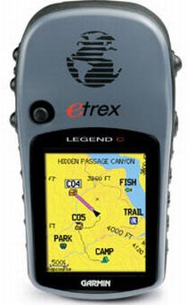
LEGEND C
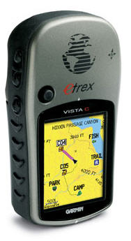
VISTA C
VISTA (H)Cx (microSD slot)
GENERAL:
The Garmin eTrex LEGEND Cx, (street price
~$205), VISTA Cx (street price ~$230), and VISTA HCx (street price -$230),
check latest prices (HERE),
are upgraded eTrex Vista/Legend packages. One major difference between
the Vista (H)C(x) with its electronic compass and the other color "Sensor"
units by Garmin, is that the unit is held HORIZONTALLY for best reception
-the only way the electronic compass can work. This is most important
for geocaching work. The Legends don't have an electronic compass,
but are otherwise similar.
Firmware Version:
Is found under, Setup, System, Menu, Software Version. Also
it's found by turning the unit on while holding down the click stick. This
also gives the diagnostics page. Pressing PAGE multiple times brings
up additional diagnostic screens.
Controls
and Memory:
The units have Garmin eTrex's familiar
"click stick" switch to the upper left of the screen along a power switch,
page switch and zoom in/out switches. We don't like the click stick
as well as the four way rocker switches on larger models BUT, on the eTrex
units, the click stick seems the right way to go considering the very compact
size of the unit.
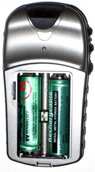
The non-x units have 24 MB of internal map
memory -the same as the old Vista. In the "x" models, one must have
a microSD card to store maps. The Vista Cx came with a 64MB microSD
card, but the HCx does not come with a memory card.
Display:
The new color display is 176 x 220
pixels and is 1.3"W x 1.7"H. This compares
with 160 x 288 pixels and 1.1"W x 2.1"H for the Vista/Legend. Thus
the color screen is not as tall, but is wider. The Vista/Legend C(x)
actually have less resolution than the Vista/Legend, see unit resolutions
(HERE).
We have criticized the text size on previous eTrex models as being difficult
to read, because the text was so small, but the Legend and Vista
Color units are considerably improved with the map and text easier to read,
and we now consider it satisfactory.
VISTA
Cx:
So what's different about this unit? "x" stands for a microSD
card for map memory storage and not for the new SIRF-III processor as in
the GPSmap 76Cx. The "x" units have been tested with up to 2GB. The
card is easier to extract than the one in the 76Cx. It's just under
the battery cover on the left and 'pops' straight out. (See picture
above). In a battery rundown test with the compass ON, the unit lasted
18 1/2 hours.
VISTA HCx:
This new Garmin (H)igh sensitivity receiver (C)olor unit contains
the (x) microSD card slot. A card doesn't come with the unit, but
a 1GB card costs only about $20. In a battery rundown test with the
compass ON, the unit lasted an astounding 30 hours! The Vista HCx's
backlighted screen is somewhat brighter than the Vista C and will hold
1000 waypoints as compared to the Vista C's 500.
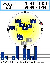
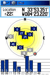
"H" Receiver Inside a House (is Obviously More Sensitive)
 .....
..... .....
.....
Vista C
Vista HCx
GPSmap 76Cx
Here we have compared the older Vista C receiver to the new Vista
HCx receiver and the GPSmap 76Cx SIRF receiver. At present, there
is some 'mystery' as to where this new receiver comes from. Garmin
tells us that they purchase from many different receiver chip vendors,
but there is a news release, "Garmin Integrates New GPS Chipset from STMicroelectronics"
(HERE).
However, an early HCx Splash Screen shows MediaTek (HERE).
NOTE: The old Vista C receiver will lock onto two WAAS Sats at the
same time (above) while the SIRF and the new "H" receivers will lock onto
only one. WAAS Sats all transmit the same corrections, so using only one
frees up using an additional GPS Sat.
Accuracy (Not too shabby
for a small unit):
The Vista units have no NMEA output, so SA
Watch can't be used to measure a definitive accuracy.
In its place, we visited a first-order survey marker in the clear.
There we placed a Vista HCx, Vista C, and GPSmap 76Cx over the marker and
took error readings every minute for ten minutes on three separate visits.
The overall averages were: Vista HCx=6.0 feet, Vista C=5.3 feet, and a
GPSmap 76Cx=7.4 feet (no significant difference in accuracy) -all well
within the expected WAAS-corrected error of 10 feet.
LIMITATIONS:
However, (as reported on the Forums) the HCx receiver has difficulty
detecting walking movements less than about 2.0 mph. The Vista C
detected movement less than 2.0 mph and recorded significantly more trackpoints
in the Normal mode than the HCx. (The GPSmap 76Cx was able to detect
walking movements less than 1.0 mph.) Also, the alarm clock available
in the Vista/Legend C(x) has been removed from the HCx.
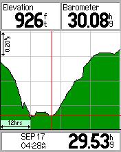
Barometric Pressure Plot
(Vista HCx):
Here the Vista HCx didn't fair so well. The below HCx pressure
plot is not as versatile as that of the Vista C, which records the pressure
even though the unit is turned off. The HCx only records pressure
when it's turned on.
Barometric Pressure Plots over About 40 Hours
 .....
.....
Vista HCx
Vista C
Barometric Pressure Plot
(Vista C):
Barometer Self Calibration
Barometer Recording of a Passing Hurricane
 ...
... ...
... ...
...
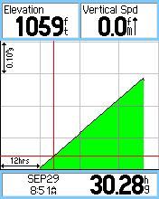
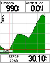
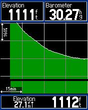
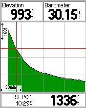
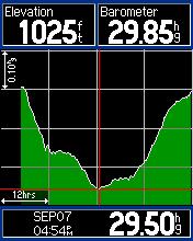
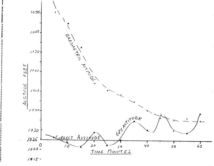
Running Elevation Plot ** Read Data
at Crosshairs ** Hurricane Francis Pressure Plot ** Click above thumbnail
In the first two screen shots, the barometer was calibrated to 1500
feet (in the Fixed Elevation mode), where the actual altitude was about
1,100 feet. In approximately an hour and a half, this large error was basically
wiped out. Under normal conditions, it only takes about 30 minutes
to Auto-calibrate the barometer to within 0.02 In-Hg of the correct barometer
setting. The above plot also can be displayed as a function of distance
traveled. Moving the Click Stick activates movable crosshairs to
read out Elevation and Time along the plot. The above plot is similar
to (THIS)
plot of the GPSmap 76S barometric and GPS altitudes with only 100-foot
initial calibration error.
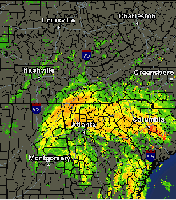
The second two pics are a screen shot of an actual pressure plot
of Hurricane Francis (and Ivan) as it passed
by Atlanta and a screen capture of the hurricane. This hurricane
was 'excruciatingly' slow moving. The center of the storm passed
near Atlanta at about 5:00pm on Sept. 7, 2004, and the GPS recorded a low
pressure point of 29.50" at that time. In order to get this plot,
the unit was connected to a notebook computer for two days via the USB
cable, which provided uninterrupted power. However, I discovered
later that the unit can go for at least a month (without any external power
and turned OFF) and still record the pressure.
GPS Altitude:
Unlike the GPSmap 76S, the GPSmap 76CS(x) and Vista (H)C(x) don't
show a continuous readout of GPS altitude. All the data fields show
barometric altitude. GPS altitude must be accessed from the Satellite
Page by pressing Menu Key, then select GPS Elevation. This
is a "one time" reading, and is not continuous.
A similar procedure is required in the original Vista. However,
the Vista does not have a "barometer" function, only Barometric Altitude.
In the Auto-Calibrate mode, the Vista (H)Cx GPS altitude does appear to
calibrate the barometric altitude, as shown below. And contrary to
the Vista's original Normalized Pressure, the Vista C's Barometer doesn't
go up and down when you go down and up!
In the Altimeter Setup, there is a selection of Variable Elevation
or Fixed Elevation. The reason someone would want to used a Fixed
Elevation, is that any fluctuations in air pressure would be seen as air
pressure fluctuations, not altitude fluctuations. This allows the
Altimeter to function as a standard barometer. (See above for an
example of the Pressure Trend mode set to Always -then it records even
when the unit is turned off.) Elevation trip data isn't recorded
in the Fixed Elevation mode.
MAPS:
Garmin recommends City Navigator maps for the (H)Cx rather than
the City Select maps, recommended for the other units. It appears
that all "x" units support City Navigator maps. These models require City
Select or City Navigator, for automatic car navigation, but can also
operate with MetroGuide maps, blue charts, and World Map and other Garmin
map products. eTrex models come pre-loaded
with a regional basemap for the part of the world where the unit is purchased.
Descriptions of the USA (Americas) basemap can be found (HERE)
and the description of the European (Atlantic) basemap can be found (HERE).
Included in the kit is a copy of Garmin's Trip and Waypoint Manager CD
which permits download/upload of waypoints/routes/tracks to your IBM compatible
PC.
COMPASS: Tests
of compass accuracy will be published when we can get repeatable results.
The
Legend C model does not have the electronic compass and barometer, included
in the Vista C and HCx, which are otherwise similar.
Functional GPS receiver
for Hiking and Automobile use?
We do agree that eTrex LEGEND and VISTA are easy to learn,
not-so-easy to use, but fully functional in getting you from A to B.
It is accurate and provides all necessary functionality for hiking use.
The extremely small package is coupled with good battery life. Battery
life was measured at 29 hours for the Vista C with the backlight and compass
OFF and 18 hours with the compass ON.
What's New and Different
in the eTrex Vista and Legend Color?
The eTrex Legend and Vista have been around for several years now
and constitute one of Garmin's larger sellers. Now comes Garmin with
the eTrex Legend and the Vista Color units. These are Garmin's latest
in the medium cost eTrex line but enhanced with automatic CAR NAVIGATION
features, improved battery life and a good color display that is easy to
view in bright sunlight. These models are the SMALLEST, and among
the least expensive car navigator units we know of as of August 2007.
WAAS:
The Legend/Vista were the first Garmin
model GPS receivers to offer (WAAS).
These new models continue this tradition. WAAS give best case accuracy
of approximately 3 meter position error (95% confidence).
Selected screen shots are shown (HERE).
Note: The screen shots file contains about 50 jpg photos and is about 1.5
megabytes in size.
Note:
The eTrex Color units do NOT have a standard serial port. Thus they
have no NMEA capability. They use a USB interconnection to a computer
for map uploading and waypoint/route/track downloading. The Garmin
MapSource systems can use this USB data to allow position tracking on Garmin
MapSource maps on a PC. Also, the units are powered by the PC when
connected by the USB cable.
The Vista (H)C(x) models have two options for
the barometer feature. They can either be set to act as an aneroid
barometer OR it can be set to be used to stabilize the (normally fluctuating)
GPS altitude. The older eTrex eliminated the "Remarks" feature
from waypoint names. However, the Legend and Vista Color allow 24-character
waypoint comments. Also, all waypoints created in the units include
the time of creation in the remarks.
ROUTES and MAPS:
Vista and Legend can upload ALL of Garmin's digital mapping products.
A major new feature is the ability of both Legend Color and Vista Color
to automatically generate a route from current location to a destination
address input by the user WHEN either City Select or City Navigator digital
maps are installed in the GPS. The destination can be (among other
things) a street address, city, street intersection,
POI, hospital, police station, and etc. The map area
that can be loaded into a GPS depends on the road system in a state,
and internal memory. The non-"x" models have 24 MB memory.
If no map is installed, the units will auto-route on the base map.
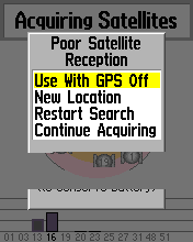
Hard Reset:
With the unit turned off, press and hold the follow buttons: PAGE
+ Enter on the click stick. Then press and release the POWER. The unit
will power up asking if you want to release all user data. Select yes,
and the unit will be reset. After the master reset, place your unit
outside, so that it has a clear view of the sky for 25 to 30 minutes for
the unit to acquire new almanac data.
What about regular
GPS features?
The eTrex model series are designed with a new "non technical" GPS
user in mind. However, the Vista and Legend have a
complete feature set for hiking and motoring. Standard
features of Legend and Vista include: Sun and Moon predictor, Calculator,
and "Best time to hunt and fish". A list of major features
and descriptions is given below. Garmin's Fishing Hot Spots maps
also are not compatible with eTrex.
Other
Features of Interest Are:
-
Satellite page - Shows usual map
of satellites in view, signal-strength bars, present-position coordinates,
and a unique indicator of the direction the GPS is pointing, or above a
selectable speed limit, the direction the GPS is moving.
-
Trip Computer - Accuracy of GPS,
Bearing, Course, Distance to Destination, Distance to Next, ETA at
Dest., ETA at Next, Elevation, Glide Ratio, Glide Ratio to Next,
heading, Odometer, Off course, Pointer, Speed, Speed-Maximum, Speed-Moving
Avg., Speed Overall Avg., Sunrise, Sunset, Time to Dest., Time
to Next, Time of Day, To Course (steering), Trip Odometer,
Trip Time-Moving, Trip time-Stopped, Trip time-Total,
Turn (direction indicator), Velocity Made Good, Vertical Speed,
Vertical Speed Dest., Waypoint at Dest., Waypoint at Next.
Any of the above may also be selected for display on the Trip Computer
page.
-
CrossTrack Error is available when
COURSE POINTER is selected on the compass page.
-
Mark Waypoint - Allows automatic
input of current location as waypoint and editing of name, Lat/Long,
GoTo, and Show on Map.
-
Find - Allows FIND of Waypoints,
Addresses, Favorite Places, Cities, Expressway Exits,
Points of Interest, and Intersections.
-
Color display: New screen has high
visibility in sunlight without using backlight. Backlight IS required indoors
or in other low light conditions. Turning the backlight ON draws
about twice the current from the battery thus reducing battery life markedly.
-
Routes - Allows storage of up to
20 routes with up to 50 waypoints in each route.
-
Tracks - Unique new feature allows
you to SAVE tracks based on: a) Entire LOG or b) you can use the click
stick (rocker) key to select the beginning and end of the saved track.
-
Setup - Allows input of Time,
Measuring units, Datum, North Reference (true, magnetic, grid,
user), and other system information.
-
Accessories in Setup - Calendar,
Alarm Clock, Calculator, Stop Watch, Six different Games, Sun and
Moon predictor, and "Best time to hunt and fish"
-
Games - Some of the six games are
actually played on a field (or parking lot) using the GPS as a tool.
Use care that your game does not cause you to dart into traffic or other
dangerous situation.
-
Satellite Screen is in PAGE sequence
and shows signal strength and utilization of up to 12 satellites in view
which includes SAT 35/47 WAAS.
-
Track up or North up operation of
map display
-
Map Display screen has two to four user selectable fields allowing any
of the above variables mentioned in TRIP COMPUTER above to be displayed.
-
Pan and Zoom can be operated at
the same time, and you can place a waypoint at the "panned"
(pointed to) location.
-
Setup allows you to select the number
of trackpoints you want to be able to save. 3000 trackpoints is the
default setting. Adding (up to 10,000) recorded trackpoints uses
map memory.
-
Setup Map allows you to select which
of the loaded map sections to display. (Useful when overlapping map
sections are loaded.)
-
Compass screen shows your direction
of movement and points to next waypoint when you are routing or have an
active GoTo. (In the VISTA model, you do not have to be moving
for the compass function to operate.)
-
Guidance Method - Follow Road (for
automatic road navigation), Off Road (for hiking and other Offroad
activities) and "Prompted" (asks you every time which mode you want) are
available.
-
Unique "Rocker/Enter" switch (above
display, upper left) allows fast movement amongst screens and features
(once you get used to it). This switch was formerly known as the
"click stick" in earlier eTrex models.
-
Screen illumination timeout has
15, 30, 60, 120, and "always on" timeout settings.
-
Centralized RESET is available on
the trip computer page. (Press Left Lower button for options.)
-
Waypoint REPOSITION allows the user
to move an existing waypoint to the current position.
-
Add to ROUTE allows the user to add a newly marked waypoint to any existing
route via the Mark Waypoint page option.
-
Calendar (built in) allows user
to add notes.
-
On Screen KEYBOARD makes data entry much simpler.
-
Direction (angle) data fields can
be set to either degrees or cardinal letter (NEWS).
-
Track Log system is complete with
Start/Stop, wrap when filled, Auto/Time/Distance record methods.
-
Built in Search for: Cities/Exits/Addresses/Intersections.
-
User can build a ROUTE by dropping
points on the map (Route page map button).
-
Welcome page allows user customization
including inserting the user's name/address, etc.
CLICK
HERE to see typical screen images with explanations (1.5 MB to load)
Note: There are usually some "hidden options" available on display
screens by pressing the Find/Menu key.
A few less used features (or features Garmin considered non-essential
for Hikers or Motorists) are not present in Legend and Vista.
battery hours timer, and user timers, are among the missing.
There is a new stopwatch/lap timer feature Both the Legend and Vista Color
have 24 megs of map memory which will be enough map memory for "many"
people. (Personally, Jack and Joe were never quite satisfied
with the available amount of map memory until the vendors came out with
units (such as the StreetPilot 2610) which could use 2 GB CF cards or micro
Hard Drives.)
What do we think about eTrex LEGEND
COLOR and VISTA COLOR?
These offer almost everything a hiker/motorist needs to navigate.
Automatic best-route calculations, and the electronic compass can be used
in the units' most sensitive position.
Even though these are not marine units, they include a HIGHWAY PAGE
which makes the units much more useful to marine users as it can be used
to give left/right steering information. The VISTA unit has useful
and interesting elevation profiling features that will be of great interest
and use to hikers, glider and soaring enthusiasts, and private
pilots among others. These Vista elevation features include a "trip
profile" in elevation much the same as your bread crumb trail gives you
an (x,y) profile of your horizontal travels. In addition, altitude
data is stored as a part of the tracklog so you can do post trip analysis
on your voyage in (x,y,z) coordinates. Waypoint Averaging is also
featured in the units.
Is VISTA COLOR/LEGEND COLOR ROBUST?
Is it WaterProof?
Like other Garmin units in current production, they are rated
for submersion to 1 meter for up to 30 minutes. We did not try the
submersion but Garmin has a reputation of replacing or repairing any unit
found to leak.
There has been discussion as to the degree of "waterproofness" of
Garmin GPS receivers and especially the eTrex and Summit (Legend and Vista
use essentially the same package). Here is Garmin's statement on
waterproofness:
Garmin reports: "Our specifications for eTrex are that it is
waterproof per IEC529-IPX7. IEC is a European specification published
by the International Electrotechnical Commission. It is very similar
to the Japanese Industry Standard JIS-8. IEC529 gives
an excellent breakdown of the relative degrees of protection against water
ingress. IEC529 specification can be found (HERE) A layman's
breakdown of IEC529 can be found (HERE).
Highlights:
Elevation
Profiling features:
- Real time plot over time and distance.
- Zoom in/out elevation profile
- Review individual elevation points with time and date
- Current ascent/descent rate
- Total ascent/descent (Resetable)
- Average ascent/descent rate
- Min/Max ascent/descent rate (Resetable)
- Min/Max elevation (Resetable)
Barometric Altimeter Features:
- Accuracy: 10 feet with proper calibration (user and/or automatic
calibration)
- Resolution: 1 foot
- Range: 2,000 to 30,000 feet
- Pressure: 48 hour automatic pressure trend recording.
Electronic Compass:
- Accuracy +/- 5 degrees with user calibration
- Resolution 1 degree
- Built in LEVEL sensor aids compass reading accuracy. GPS
must be held LEVEL to read compass accurately.
- Compass operates in both North Up and Track Up map modes.
- Automatic Declination adjustment with manual override.
LEGEND and VISTA C(x)
Feature Highlights:
Sight 'N Go:
- Sight and locked in a bearing
- Navigate along course by following CDI with off course information.
- Sight and project a waypoint, and navigate to it.
Track Log:
- Automatic elevation and track logging (3000 points)
- Save up to 10 tracks (along with elevation profile) with 250 points
each
- Note: Clearing track log will also clear elevation profile
Options/Settings:
- Option to show/hide waypoint
- Option to display heading using big numbers
- Option to set different units for distance/speed, elevation, and
pressure
- Options to turn on/off GPS and Compass (saves power when entering
data)
Other Features:
- Automatic map rotation, Track Up or North Up.
- Create new waypoint by projecting from an existing waypoint
- 500 Waypoints (with Icons/graphic symbol, and name)
- 50 reversible routes with up to 250 waypoints in a route.
- Trip Computer with current speed, average speed, sunrise/sunset,
max speed, trip timer and trip odometer
- Position format has Lat/Long, UTM/UPS, Maidenhead, MGRS,
and other grids, one USER grid, and one USER Datum.
- Receiver is 12 channel parallel and operational with the WAAS
system.
- WAAS accuracy is in the range of +/- 3 meters 95% confidence.
- Antenna is slightly smaller than on larger Garmin units, but gives
sensitivity almost equal to the larger Garmin receivers.
- No external amplified antenna connection port is available.
- Legend and Vista C(x) have only 6 control buttons,
one a "clickstick", for easy one-hand operation.
- Interfaces: proprietary GARMIN USB only.
- 108 map datums
Specifications:
- Position Error: <15 meters 95% typical.
- Acquisition Times: Warm ~15 sec, Cold ~45 seconds, Auto
Locate ~2 minutes (longer in non clear-sky situations.)
- Speed Accuracy specification 0.1 knot RMS steady state
- Physical Size: 4.4"H x 2.0"W x 1.2"D (11.2 x 5.1 x 3.0 cm)
- Weight: 5.46 ounces (155 g) with alkaline batteries
- Display: 1.7"H x 1.3"W (4.3 x 3.3 cm) high contrast TFT LCD 256
colors, sunlight viewable with bright backlighting
- Case: Waterproof to IEC 529 IPX7 standards (Immersion to 1 meter
for 30 minutes)
- Temperature range (operation): 5°F to 158°F (-15°C
to 70°C)
- Data storage: Indefinite; no memory battery required
- Power Source: 2 AA batteries or via the USB cable or via
the accessory cigar power cable.
- Update Rate: Once per second, continuous
- User Waypoints: 500/1000
- Trackpoints: Up to 10,000
- Saved trackpoints: Up to 500
- Saved tracks: 20
Specific questions answered:
-
Where can I find the LATEST LEGEND COLOR MANUAL?
HERE:
VISTA COLOR Manual? HERE.
-
Does it support UTM/UPS? Yes. MGRS?
Yes. NMEA? No.
-
Does it have user grids? Yes.
-
Can it measure distance between waypoints in
a route? Yes.
-
Can I upload all types of MapSource maps? Yes..
-
Can I use an external antenna? No
(except the Tri-M re-radiating antenna.)
-
Is there a power/data cable so I can hook up
my computer and external power to the eTrex? Yes.
-
Does the VISTA or LEGEND have an audio (spoken)
alarm? No.
-
Does the VISTA and LEGEND allow me to turn
"Road Lock" on and off? Yes, using On Road/Off Road modes.
-
Does the VISTA and LEGEND "lock" the routes
to roads like StreetPilot models? Yes.
-
Do the VISTA and LEGEND allow you to FIND cities,
intersections, addresses? Yes.
-
Are there any special requirements to use WAAS?
Yes. You must turn Power Save OFF and WAAS ON.
-
Can I change color schemes for the display?
Yes.
-
Can I change the page sequences and which pages
are normally displayed? Yes.
-
Can I turn the "Next Turn PopUp Window" OFF
if I do not want to use it? Yes.
-
What special features are available for Marine
use? An "Off Course" alarm and an "Anchor Drag" alarms.
-
Does the units have automatic daylight saving
time? Yes. And apparently it is operational worldwide.
-
How do I turn the Compass ON and OFF?
You hold the PAGE button for a few seconds.
-
How do I MARK a waypoint? You press the
"clickstick" down and hold it for a few seconds.
-
How many data fields can be put on the map
page? None, two, three or four, user selectable.
-
If I take the eTrex up in a pressurized airplane,
will the GPS altitude be displayed? No.
Technical Questions? Comments? Additional Info we should add?
Contact: Joe
Mehaffey - Jack
Yeazel
For: How Do I operate my GPS? See: news:sci.geo.satellite-nav