A Review by Joe Mehaffey and Jack Yeazel
Return to GPS General Information Home Page
(Add new review of GOLD travel kit using DirectRoute Maps: 25 August 2004)
A Full Featured GPS Receiver
A Full Featured GPS Receiver
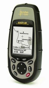
The Magellan GOLD (Ver. 2.09) Mapping GPS receiver (about $300US, check latest prices HERE) is a full-featured and medium cost receiver with a built-in 16 MB basemap (competitive units have 8 MB, Meridian basic has 2 MB) showing worldwide political boundaries, U.S. cities, highways, major roads, national parks, waterways and railways. The GOLD also has a slot for another 8 to 128 megabytes of flash "SD" memory available for uploading detailed street maps, waypoints and routes from Magellan's new MapSend Streets CD-ROM (sold separately). SD memory from vendors other than Magellan will operate in the Meridian units.
It's a competitor to the Garmin GPSmap 76 and eMap but with substantial hardware improvements. The GOLD is rated IPX7 (submersible to one meter for 30 minutes) and it floats. Also see a review of the Magellan Platinum which is a competitor to the Garmin GPSmap 76S.
Despite the reasonable cost and conventional design, the GOLD is a step forward in mapping GPS products. While Garmin has used "product differentiation" by equipping low-cost models with small but irritating feature deficiencies while NOT offering a "full featured model with large map memory", Magellan apparently decided to offer customers an attractive alternative.
Even though it does not offer automatic highway routing, the GOLD offers all of the features (and then some) that we feel are essential for hiking and highway and marine navigation along with a large (optional at extra cost) plug in map memory and a robust and and secure case at an attractive price. While the GOLD offers all of the important features of its similar cousin, the M-330, and it has a similar user interface, GOLD is equipped with LOTS of customizable features and the decided advantage of a 64 meg (optional) user uploadable map memory and a high quality 16 meg base map. Larger than 64meg memory modules will work, but Magellan now supports up to 64 megs of user map memory.
The GOLD has a number of features that are lacking in most other GPS receivers and they are ALL in ONE instrument! For example: adjustable tracklog time intervals, waypoints, tracks, POIs, and topo lines can INDIVIDUALLY or globally be turned on and off.
A FIND waypoints, addresses, cities, highways, parks, waterways feature is provided. You can even ask for the FIND to work "nearest the cursor" instead of nearest present position. There are 8 sequential user screens. You may turn any you do not want to use to OFF so the sequencing will take less time. Fixed elevation (2D) or GPS elevation (3D) modes can be selected. All of arrival alarm, anchor alarm, XTE alarm, and GPS Fix alarm are available. The GOLD can be programmed to automatically turn itself OFF if signals are lost for a user selectable period. We think these are an exceptional addition to the feature list of a single GPS!
Meridian (basic),
Gold, Platinum, and Marine -What are the differences?
The differences between Meridian GPS,
Gold, and Marine are the built-in base maps. The basic Meridian GPS
has a 2 MB basemap, while Gold and Platinum have a 16 MB basemap.
The Marine also has a 16 MB basemap but with emphasis on some built-in
navaids. Meridian Platinum is a Meridian Gold with a built-in 3-axis
compass, barometer, and temperature sensor. (Note: The "three axis"
compass means that you DO NOT have to hold the Platinum in any particular
position for the compass to read correctly (unlike the VISTA where you
have to hold it level for the compass to function.) Also, the
barometer functions as a barometer and is not used for altitude smoothing
and readout as in VISTA.) Note: The BASIC model has a limitation
that users should understand.
Magellan can change a GOLD into a MARINE and vice versa, but this is a factory operation for a charge due to software licensing issues. If you would like to take a look at the Meridian Manual, (basic, GOLD and PLATINUM), Magellan has given us permission to provide the manual in an 8 MB PDF format (HERE) but there may be a later copy available on their website.
WAAS Compatibility
The Meridian GOLD and family is WAAS and
EGNOS compatible. In addition, Magellan has elected to ignore
the present "do not use" flag produced by EGNOS signals (the WAAS for Europe)
and allow corrections to operate in Europe. Users should be aware
that these signals MAY not be reliable at times
Tracks and Trackback
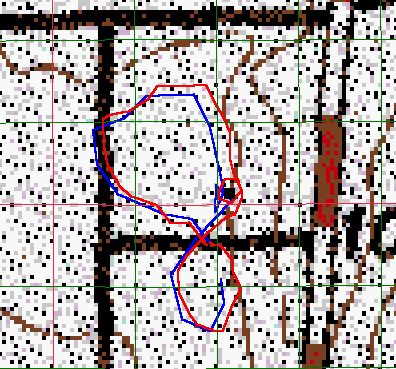
The walking tracklogs (up to 2000 points)
are fairly good with GOLD. When set to the maximum resolution
setting, the plot (improved over the M-330) still does not have quite
the resolution when compared with the Garmin VISTA. (HERE)
is a comparison with a VISTA while walking a pattern including a
small 50 foot diameter circle (around a black square waypoint). The
Vista laid down 56 trackpoints while the Meridian laid down only 20.
As with all Magellan's, non-existent track lines are drawn between where
the unit is turned off (or loses lock) and where the unit is turned on
(or regains lock). With the latest firmware, the Meridian units
allow the user to store as many tracklogs as desired (up to memory
limits) into the SD memory card.
When it come to trackback, Magellan has a significant advantage over the Garmin implementation. The Garmins select only a few percent of the trackpoints to use in the trackback directions, thus tending to "cut corners". This (from personal experience) can cause one to run aground when following a curvy river in low visibility. In the Magellan implementation, each and every trackpoint is used in the trackback steering directions. The GOLD only shows you the FIRST (or NEXT) trackback point to keep from cluttering up the screen. Once you pass the indicated trackback point (as "BP0603"), then the compass page, the 3-D highway page, and Map page indicate the bearing and distance to "BP0602" -and so forth. (BP= Backtrack Point). A comparison of the trackback implementations is shown (HERE).
Routes
One can convert a track log to a
traditional 30 leg route. This will allow you to convert a track
to a route and then begin another track (after you clear the current track
file). So, you can, in effect, have many tracks saved, just in a
30 leg route form. You also can use all of the route editing
features after the conversion is complete. NOTE: Meridian units
automatically "name" a TrackBack route: "T_track-number_P_beginning-point-number
T_track-number_P_ending-point-number"
which can't be easily changed.
The "Arrival" alarm can be set from 100 feet to 1.0 mile. One must use the GOTO feature to select an arrival waypoint. There is no way to select a number of waypoints and make them "proximity" waypoints like the Garmins that can have 10 proximity waypoints -such as the G-12XL and GPSmap 76. The lowest proximity distance in the G-12XL is 0.1mi and the 76 is 0.01mi -up to 100 miles.
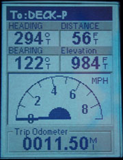
The Speedometer Screen
This unique screen shows your current
speed and other data. A feature not shown here is a second larger
shaded arc appears when under way, which is your average speed since the
unit gained lock. Once your speed increases, the scale of the speedometer
increases automatically.
Magellan Meridian Maps
NOTE: The
new MapSend
DirectRoute maps will provide more accurate maps than those mentioned
below plus provide automatic routing and a USB card-reader function.
Magellan also offers MapSend: MapSend Streets and Destinations, Topo
USA, and Topo 3D USA mapping systems for the GOLD. (See comparison
map samples (HERE).
 ..........
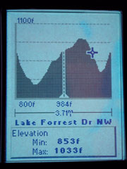
Calculated Contour Lines
Street Profile of Displayed Street
With the MapSend Topo USA map installed, an elevation profile of the path immediately ahead can be displayed. The vertical profile of track history, route, or street can also be displayed. A topo map of the world is planned for the near future. In the screen shots above, the cursor has been moved from present position -in which case the cursor turns into a cross. The center of the profile is present position indicating 884 feet altitude and 853 feet at the cursor. The cursor always reports the altitude of the cursor when not placed on a street. If placed on a street, the street name is displayed.
The Magellan TOPO map system, see review (HERE), is necessary for the operation of the elevation profile features. MapSend Topo provides the same detailed street and park data offered in MapSend Streets and Destinations and adds detailed topography and outdoor points of interest covering dozens of categories within the outdoor arena.
The MapSend Streets (ver 1.00) that we evaluated initially was easy to use and includes an important feature missing in Garmin's MapSource. To select a map area for upload, the user positions the cursor in the upper left of his desired area, holds the left mouse button, and then pulls the cursor to the point where he wants the other diagonal of a box to fall. MapSend generates a rectangle of this arbitrary user specified area. The user NAMES this map area and then can select other map areas for upload. Magellan's GOLD (like other manufacturers units) automatically erases map memory prior to uploading new maps. The GOLD can hold a maximum of FOUR separate and distinct user outlined map "areas" up to the max map memory.
Map memory is optional and available up to 64 megs. Note: In our MapSend Streets, it is possible to upload 4 map "areas" and each "area" can be a max of 16 megs. Thus, to fully load a 64meg memory, the user must select 4 different areas even if the areas are directly adjacent. Magellan says later updates of MapSend will allow a single upload of up to 64 megs. The memory cartridge can also be loaded directly using a computer much faster than it can over the serial link. See (HERE) for details. As of Jan. 2002, MapSend Streets cannot create automatic address to address routes for download to a Magellan Mapping GPS.
Magellan continues its highly competitive price point for computer uploadable street maps by pricing the MapSend STREETS at $50US. The GOLD "street price" with a data cable will run about $300US Check latest prices (HERE). Note: The DataSend POI product designed for use with the M315/320 is NOT compatible with the M-330/GOLD. Check the map detail setting on the GPS after loading new maps. The detail on ours was set to low detail and few local roads were not shown until we set the map detail to higher detail levels. The base map of the GOLD is generally superior to that of the Garmin units. It contains (some) local streets, more rivers and railroads, plus considerably more lake shoreline detail and POI content.
MapSend Streets and Destinations for the United States (now available) offers detailed streets, lakes, rivers, parks, and over 30 categories of points of interest covering the entire 50 states. MapSend Streets and Destinations provides information in both metropolitan and rural areas.
MapSend Streets USA (used in this review), see comparisons (HERE), is an earlier version of what is now called MapSend Streets and Destinations for the United States. It is the first version of MapSend released and was distributed with the MAP 330 series of GPS receivers. It has most of the features of its successor except for the lack of points of interest and specific Meridian support. To use this with Meridian, you will need to download the MapSend update for Meridian from the Magellan website (when available).
It's interesting to note that the Meridian displays the street you are ON in addition to the upcoming cross street. Doing that with the Magellan MapSend Streets (which are related to the Garmin R&R maps) is an innovation not available with the R&R maps, but available in Garmin's more expensive maps.
Don't forget that a SD memory Card is necessary to load any USER maps from TOPO or MapSend Streets.
A complete list of maps
available include:
MapSend Streets USA (used initially in
this review).
MapSend Streets and Destinations for the
United States (used in the
SporTrak Pro review).
MapSend Topo for the United States (also
used in this review).
MapSend Topographic WorldWide BaseMap
(coming soon).
MapSend Streets Europe -provides detailed
street, waterway, and coastline information for Europe.
MapSend Streets and Destinations Canada
(soon to be released) -To provide the same types of information as MapSend
Streets and Destinations for the United States .
MapSend CD Functions
MapSend allows the user to position waypoints
on the PC based map and then later place two or more of these waypoints
into a route. The route and waypoints (and tracks) can then be uploaded
to the GOLD. Likewise, downloading of routes, tracks
and waypoints FROM the GPS to MapSend is available. MapSend
allows you to FIND a street address, city, town, airport,
parks, etc. using the PC program. You can then place
a waypoint at a particular street address or other point of interest, and
the GOLD can also can FIND street addresses in the GPS itself. The
GOLD has an extensive POI database. There are a few operational
problems with current (December 2001) versions of MapSend when operated
with the Magellan Meridian units. The latest version of MapSend is
said to correct the problems and should be used with Meridian (and Sportrak)
models. (HERE)
is a temporary file with Magellan's latest protocol document which supposedly
includes the GOLD.
MapSend (like Lowrance) does NOT offer real time tracking capability such as is offered by Delorme, Garmin and others. Map assembly and loading (an automatic process) is rather time consuming compared with MetroGuide and an eMap. It takes about 15 minutes or so to convert plus about 10 minutes to upload an 8 meg map of the Atlanta area into GOLD. (This using a P-II, 400mhz, 96meg computer. Conversion is about 2 minutes on a 1GHz computer.) This is the price of user flexibility and provides for the flexibility of being able to select large or small map sections of one's own choosing for upload. (Note: If you have room on your hard drive to do the "full install" of the 650meg MapSend program, Map conversion time is reduced by more than half.) Once a map conversion has occurred, MapSend stores the "converted" map section so that on future uploads, reprocessing the selected map section is not required. The initial handshake with the GOLD is at 4800 baud, but the system switches to higher speeds up to 115kbaud for map upload if your computer will accept this high speed. Many computers can operate reliably at 115kbaud with the GOLD if the GPS has relatively fresh batteries.
If one is uploading DirectRoute maps, a USB SD-card reader will speed up the process, but only for the DirectRoute maps. None of the other maps, such as Streets and Destinations, Topo USA, and Topo 3D USA can use a card reader.
Keyboard Controls
The keyboard contains the usual buttons
on the lower half of the unit, PWR, ESC, NAV, GOTO, MENU, ENTER, IN and
OUT (zoom), plus an up/down/left/right rocker switch. The buttons
are easy to push and the layout comfortable. The NAV button cycles
the navigation screens in one direction, and the ESC button cycles them
in the other. There are eight NAV screens including one
Map Position screen available. Similar to the Garmin units,
screens are selected in sequence with the NAV or ESC button rather
than from a menu. Holding down GOTO is used to mark a waypoint.
There is little delay between screens in the GOLD. The GOLD (like the M-330) maintains a map memory cache somewhat larger than the screen display so panning to areas a short distance off the displayed screen is fast and smooth. Redisplay of a fresh map section when you pan beyond loaded map extent is typically about 2 seconds. (Much faster than most).
Battery Information
The GOLD has no battery selection setting
but NiMH and Alkaline batteries both work well. The battery level
meter shows about 95% full on NiMH and 100% on Alkaline when fresh batteries
are installed. Magellan has been listening to the complaints of "my
GPS turns OFF when I drop my GPS" prevalent with some Garmin units.
Magellan has designed a system using a dual spring system which appears
to have eliminated this annoyance. A very vigorous "jar" to a wood
table top on any side of the unit had no effect on operation of the GOLD
unit. Alkaline battery life is specified at "up to 14 hours",
but we got more like 12 hours of continuous operation on several sets of
Alkaline cells. The battery drain was measured as 145 ma with regular
alkaline batteries. This would indicate about a 12 hour battery life
(or 24 hours for four AA batteries normally required in many GPS
units). Note: For typical GPS applications, Lithium or
Alkaline batteries have the most available energy. Rechargeable batteries
of all kinds have less but the new 1800 NiMH rechargeable batteries are
close and with lower lifetime cost.
MENU options
Pressing the MENU button brings up a common
(and well organized) menu on all screens. The main menu offers selections:
Database, Routes, Setup, Vertical Profile, Sun/Moon, Fish/Hunt, Contrast,
Alarms/Msg, Help, and About. Some screens offer other options such
as Track Clearing, Find Nearest, Customize Display, etc. as
appropriate. The GOLD continues the M330's unique "tips" screens
which offer advice and information on using the GPS. We found this
feature quite handy when first getting familiar with the unit.
The NAV and MAP screens are customizable with a selection from fourteen
navigation data readouts. These include: bearing,
heading, distance, speed, VMG, CTS, ETA, ETE, XTE, TURN,
Elevation, Date, and Time. The Position screen
can be alternated with the Lat/Long screen with the Left/Right rocker.
Like the M-330, GOLD can pan and ZOOM at the same time. One
momentary push of the PWR button is all that's required to turn the power
OFF with a 4 second time-out. Holding the button for several seconds
turns on the display and keypad lighting. See some of the screens
and a comparative size photo of competitive GPSRs (HERE).
Waypoints
Waypoints are created by HOLDING the GOTO
button which assigns an automatic serialized name of 'WPT 001' and
etc. (The unit allows you to MARK a waypoint even when it is not
locked so be careful.) A "keyboard
matrix" of letters, numbers, and punctuation allows very EASY user
entry of up to 8 character waypoint names and a 20 character comment
message to go with the waypoint if desired. We REALLY appreciate
the ease of use of this name entry method compared with the means used
by other brands. With the GOLD, you can even use upper
and lower case letters and special characters such as @#<%, etc.
in a waypoint name to perhaps reduce screen clutter. Waypoints can
be turned on or off as an all or none function.
If the GOTO button is pressed only once (and fairly quickly), the GOTO function is entered. The user can then select from user waypoints, nearby cities, highways, airports, waterways, national parks, etc. If Database > User (waypoints) is selected, either Nearest or Alphabetical lists are available. A feature allows viewing any selected waypoint at its map location.
NMEA
Three variations of NMEA sentences are
selectable: Mode "1.5 APA": APA, BWC, GLL, & VTG; Mode
"1.5 XTE": BWC, GLL, VTG, & XTE; and Mode "2.1 GSA": APB, GGA*, GLL,
GSA*, GSV, RMB, & RMC*. The (*) indicates sentences required
for real-time tracking by Street Atlas.
Compass and Sun/Moon Screens
The GOLD's compass screen contains a unique
display of the sun and moon positions (when above the horizon). With
this information, one can point the sun icon to the sun (or moon icon to
the moon) and determine approximate true north without the necessity of
moving or using an accessory compass. The Sun/Moon screen shows the
current (or past/future/different-location moon phase, and sun/moon rise,
and set times.
Third-Party Software Compatibility
This version of the GOLD can exchange
and store data with OziExplorer, Street Atlas (SA) 8 and 9, Delorme
TOPO, MapSend, and possibly others.
Ozi Explorer (set to Magellan Meridian XL) will exchange waypoint and track data with the GOLD and handle waypoints with eight characters (the limit of the GOLD). With Ozi one can download Garmin waypoints and then upload them to the GOLD provided the waypoint icon number is less than 57. Ozi Explorer, SA 8/9, and Delorme TOPO can download and display tracks from the GPS. Ozi can upload them back to the GPS, but SA 8/9 and TOPO cannot.
Waypoints can be uploaded from Street Atlas, but the waypoint names are truncated to six characters. However, the full name appears in the "Comments" field. If SA 8/9 is used to generate a route and an attempt is made to upload the route, the waypoints associated with the route upload fine, but the route does not. Icons are replaced by a default square box. Apparently in order to exchange data with Street Atlas, one must select NMEA mode 2.1.
General "Touch and Feel"
Observations
The first thing you notice about the GOLD is its "husky" size and
that it is a bit heavier than some. It weighs about the same as the
G-76map. It weighs about 8 oz. (~210gm) with its two
AA batteries. (The 315 weighs 6.5 oz. The comparable
Garmin eMap weighs 6.7 oz.) The GOLD (like the M-330, M315 and eMap)
also use two AA batteries. Battery life of the GOLD is quoted at
"up to 14 hours" but we got about 12 hours, same as for the
eMap. The units are approximately the same size. Screen
resolution of the GOLD is 120 x160 pixels whereas the M-330 is 104 x 160
pixels and eMap 120 x 160 pixels.
Accuracy is stated as 15m rms (95% confidence). Upon detecting no receiver movement, the receiver automatically goes into an averaging mode in order to refine its position estimate. If you leave the GOLD in a fixed position it will automatically power off if this mode is selected in setup. A feature not seen in most other GPS receivers is, "The best time for hunting and fishing". (Folklore or Speculation, we could not tell which.)
What other GPS features
does the GOLD have?
Sensitive 12 parallel channel receiver
Screen resolution 120 x 160 pixels
500 waypoints, 20 reversible routes with 30 legs
52 different waypoint icons are selectable for waypoint identification
Waypoints recorded include altitude of the waypoint.
Proximity alarms with audio beeper
Turn ON requires you press ENTER TO AGREE or it shuts OFF.
2 level Electro Luminescent Backlit display and keypad
Displays distance, bearing, heading, steering, speed, time to go,
elevation, XTE, time, date
Standard satellite elevation screen
2000 point Track record
BackTrack including ALL trackpoints
Resetable trip odometer
"EZstart" position initialization
12 coordinate systems: Latitude/Longitude, UTM, OSGB, USNG, MGRS,
Swiss, Swedish, Irish, Finnish, French, German and User Grid
85 map datums
Languages: English, French, German, NL, Suami, Spanish, Italino,
Portuguese, Svenska
NMEA data output for PC interface
DGPS ready
WAAS operational
It floats! IPX7, submersible to 1 meter for 30 minutes.
Memory card is in sealed compartment.
Large Pocket Size, 6.5" (h) x 2.9" (w) x 1.2" (d) / 16.5 cm x 7.08
cm x 3.05 cm
Unit evaluated: Meridian GOLD, ver 2.09 firmware, Basemap
Ver 1.0, Road Maps MapSend version 1.0
Display Size 2.2"h x 1.75" w (5.59cm h x 4.44 cm w)
Operating Temp 14F to 140F (-10C to 60C)
Accuracy is specified as 7 meters RMS and 3 meters RMS with WAAS
(Out in the clear, 95% probability)
Speed Max 951 mph
Altitude 17,500 meters
What is our overall opinion
of the GOLD?
The GOLD is a well made, well implemented GPS receiver designed
for both LAND and MARINE use. While it does NOT have present position
to address automatic routing, this unit has every other useful features
needed to make it an excellent unit for HIKING and MARINE use. It
is also equipped with a FIND feature which makes it quite useful for car
navigation as well. With its reasonable size, sturdy
construction, watertight case, large, clear and detailed B&W
screen, good quality maps, low cost and extensive feature
set, the GOLD should be one of the most popular GPSs of the
year. There are no glaring feature omissions which would cause
users problems. The user interface is very simple to use and learn.
Battery life at 12 hours for just 2 AA cells is average. (Some
users report somewhat less.) For an approximate "street
price" of $300 Magellan is currently offering the GOLD with
data cable included.. This is a good value for a superior product.
Check
Latest Prices HERE. This is a competitor to the eMap and
G-76Map and, but we judge it superior because a) it includes ALL
essential GPS navigation features for CAR, LAND, and MARINE use in a single
unit and b) it also has half a dozen new features not present in competitive
units. The present 64 meg capable memory cartridge will likely be
increased to handle larger memory cartridges in the future and 256 meg
cartridges are now available from some card vendors.
What we did NOT like about
the GOLD.
1) The compass page doesn't have a course indicator available.
2) We like to have an input for an external amplified antenna which
is not available on the GOLD.
3) Uploadable maps are limited to the (good quality) USA highway
map and to a (quite advanced technology but still low resolution) MapSend
Topo map. MapSend Europe is new, and hopefully Magellan will expand
the available maps quickly.
4) The GOLD comes with a multi-language "quick start" manual.
The complete manual comes in various languages on an included CDROM.
We much prefer a printed manual be furnished with a system.
5) Tracklogs can be saved to 20 routes, but they have a limit of
30 routepoints each where 50 in normal.
6) The relatively limited number of Datums (85) available will be
a problem for some people in remote areas of the world.
SPECIFIC USER QUESTIONS
ANSWERED (FAQ):
1) Does the GOLD have proximity waypoints? Answer: It
has an "Arrival" alarm from a GOTO selection.
2) How close can you "zoom in" with the GOLD? 100 feet is
the readout, this is about 300 feet left to right on the screen.
3) Can you use NiMH, NiCad and Lithium batteries in the GOLD
even though it has no battery type settings? Yes. Battery "rundown
time" may not be maximum for the battery type, but it works fine.
4) What Map products does Magellan have that will operate with Magellan
Meridian GPSRs? Magellan MapSend Streets and TOPO are the only
map programs that will work with GOLD. Currently available maps include
USA, Europe and Canada and these are listed in the MAGELLAN MERIDIAN MAPS
section above.
5) Does Meridian have any MARINE uploadable maps? No.
6) Can I load Delorme, MapSource, Garmin, Route
66, USGS TOPO, or any other 3rd party maps into my Magellan
GPS? No. ONLY (repeat ONLY) maps furnished by Magellan can
be loaded into any Magellan GPS receiver. Same "Manufacturer ONLY"
for all other consumer model GPS receivers.
7) How many TRACKLOGS does the GOLD have? Just ONE.
It has 2000 points in this one. However, with the latest software
you can SAVE as many tracks as you want to SD memory up to the limit of
available memory.
8) Does Meridian have TRACKBACK? Yes, and unlike Garmins that
limit the trackback points to a few percent of the tracklog, the Magellans
use ALL available tracklog points. This can be an advantage in logging
trails and backtracking.
9) Does the Meridian have "Save Track to Route" feature? Yes,
20 with 30 routepoints in each.
10) Does the Meridian allow diagonal (as opposed to right then up)
cursor movement like the G-76map? Yes.
11) Will other brands of SD plug in memory besides Magellan's work
in the Meridian? Yes. We are told that other brands will work
also.
12) When will AUSTRALIAN Maps be available for the MERIDIAN GPS
line? Magellan has offered an Australian MAP 330 for about 6 months
now. (You cannot buy this version in the USA. Due to restrictions
by the Aussie Government, the Aussie maps must be installed in Australia
by the Magellan Distributor. The data is said to be "street level
and covers the entire country. It is not quite as complete as what
you can find for the US, but it is very good for metropolitan travel."
according to Magellan. This map system can be loaded into the MERIDIAN
GPS line when it is available in Australia.
13) When will European Maps be available for EUROPE? Magellan
currently offers the MAP 330 and Meridian products to Europe with European
basemaps and a MapSend with European detailed streets. Due to royalty
restrictions Magellan says they have not yet been able to offer a simple
path for customers to convert their basemaps from the US to Europe and
vise versa. It is possible, for a fee, to do this through Magellan
Technical Support, but it is not available (legally) for user change.
14) Will Magellan offer the ability for users to change the basemap
on a Meridian GPS? Magellan says that they are hoping to offer this
capability in the coming year.
315/320/330/Meridian Contacts Other
connections
1 = Data in (pin 3 on DB-9)
yellow wire.
2 = Regulated 3.86vdc,
red wire. Absolutely DO NOT connect directly to 12vdc or your GPS
is FRIED.
3 = Ground (pin 5 on DB-9)
and ground on cigarette lighter plug, black wire.
4 = Data out (pin 2 on DB-9)
orange wire.
In case of incorrect time: Transfer
routes and waypoints to the SD card and then turn off unit and
remove card. Then start up and
clear all memory. Then put card back in and go through initialization.
============================================================================
Return
to GPS General Information Home Page
Please send corrections and comments to
Joe Mehaffey or Jack Yeazel