August 5, 2004 * A review by SeaJay Bayne
RETURN to GPS Information Main Page
The unit performed very well. Rather than give a detailed description of the exact features of the Meridian Color, a similar unit has already been covered (HERE), we will focus on the practical functionality of the unit and the features of the DirectRoute Car Navigation mapping system.
The Value Pack comes with the GPS unit itself, a 64 megabyte SD memory card, a cigarette lighter adapter, a serial port for connecting directly to a PC (the latter two in a sort of harness, combined presumably to make wire routing easier), a rather impressively-designed windshield mount, and Magellan's version of MapSend DirectRoute software.
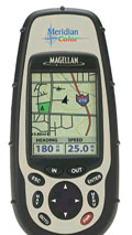
DISPLAY:
The Color has a larger display than the Spot Trak's which provides
more detail, and is easier to decipher. The Color's clear acrylic
screen was countersunk, providing some protection from scratches and
damage. The backlight feature, for use at night, had two positions
one brighter than the other. This made the screen easier to read
in all light conditions, while simultaneously providing some ability to
choose between a bright screen or a battery-saving ½ brightness
screen.
INTERFACE:
Menus are easy to understand, and the buttons more functional on
the Color than on my eTrex machines. The Color had a simple, well-labeled
set of buttons at its base (which were backlit at night) and included a
center toggle button that allowed manipulation of the screen options
with ease. Zoom features were labeled simply IN and OUT.
Feature operation seemed intuitive, and without complex menus and
side buttons, my learning curve was dramatically reduced.
OPERATION:
With a lot of waypoints already on several Topo profiles, these
downloaded into the Color without a problem. Using the DirectRoute
software, it allows one to upload a detailed version of a local road
map onto the unit's 64 megabyte SD memory card (furnished with
kit).
A moment about this process: 64 megabytes of information takes forever to upload into this machine through a serial port! It took close to an hour and a half. Magellan does offer a solution for this problem by making available the optional SD Card loader (both PCMCIA and USB versions are available), but one does not come with the GPS Traveler Value Pack, and is sold separately.
Another need is a 120vac/12vdc converter for powering the unit at the PC. For reference, Magellan says that the pair of AA batteries that power the handheld last 17 hours, but we got closer to 12 hours before needing replacement. Using the backlight feature cut that number by more than half, even on the low setting.
A word about the backlight feature: The backlight feature has a manual on and an automatic off at four minutes which is a user-definable parameter. It could also be turned off manually, but to do so I had to scroll through low then bright then off. This design could be improved; more than once we inadvertently turned the unit off. Again, the screen was larger, so one can get more information in a shorter span with the Color. In terms of usability, the Color has one of the best designs we've seen but could still stand improvement in terms of simplicity and intuitiveness.
MAPS:
The MapSend DirectRoute software proved simpler and more intuitive
than their Topo USA software. Happily, both Delorme Topo USA and
the MapSend software communicated with the Color. With this version
(5.09), you can select one large detail area of a MapSend map and upload
the entire area to the full capacity of the SD memory card.
Here's how the MapSend DirectRoute Car Navigation System works: After a user has uploaded the detailed map using the MapSend DirectRoute software (necessary so that the Color can route over all roads and by address), they press the GOTO button and select whether to route Point-to-Point (as the crow flies useful for marine and aircraft navigation) or by Street Route. It's the Street Route function that makes this handheld something very unique. A virtual keyboard appears, and using the arrow keys, a user can select letters.
FIND FUNCTION"
Spelling the name of a street, road, or highway. Once that's
been found (the unit finds the correct name automatically, then asks you
to select which one if multiple streets are found with the same name) the
Color asks you to select the number portion of the address. Such
as the 10 in 10 Main Street. To us this seemed a bit backwards,
and took some getting used to. Once the complete address has been
selected (and you've chosen which one if multiple addresses are possible
there might be a 10 Main Street in both Orlando and Savannah, for example),
then it spends a few seconds calculating the best route for you to take.
What constitutes best is not a user-definable parameter that is, you
can not tell the Color to stay on the highway as long as possible or take
the shortest route regardless of the size of the street. Thus, navigating
around town with the Color can sometimes produce routes that are not what
you know to be fastest due to the number of lights, stop signs, etc.
Other destinations besides addresses are available too, such as waypoints or previous destinations, but we've found the unit to be most useful in routing to completely new places. The easiest way to find those places is to simply key in the address. The Color then automatically selects a zoom level (which can be overridden either permanently or temporarily) and the route bolded on the map. It also shows two fields Distance and Total Distance. Distance is the distance in miles (or kilometers) to the next turn, and Total Distance is distance to your selected destination. These two fields are user-definable. A user can optionally select preferred information to display, such as Bearing, Distance, Speed, Heading, ETA, and the like. Optionally, the two fields can be disabled, although they return the next time a Street Route is selected.
The input method for doing this was quite methodical, intuitive, and effective (the Color has a data entry system similar to a virtual keyboard). This is a nice feature of the unit, and really what set it apart from its competitors in the marketplace. Other GPS units that can do this too, but Magellan's system works better and is much more through and intuitive than any other system found in a handheld.
One bug in the Color's Street Routing software was that you can select to customize these fields for example, instruct the unit to show me Heading and ETA, but these settings were forgotten the next time computing a Street Route. The fields always defaulted to Distance and Total Distance.
COMPARISONS:
All of these new features did come at a price, however. In
all fairness, the eTrex machines were significantly smaller, although more
awkward to use, due to button placement. Also, as per the Magellan
reputation, satellite signal took longer to acquire than it did on the
Garmin machines. During bootup, not only does one have to repetitively
press the ENTER key to agree to certain use of the GPS, but the unit
would simply take longer to figure out where it was. Admittedly,
though, the Color did tend to keep its signal better with more accuracy.
AUTOMOBILE INSTALLATION:
We found the suction-cupped device somewhat annoying. The
device was large and ungainly, and although we found a place on the windshield
where it would not interfere with your line of sight, it was still obtrusive,
due to the chore of having to hold a relatively weighty Color unit.
The screen, which seemed large and optimal as a handheld, was too small
to be seen with any detail when it was placed far ahead of eyesight.
The Color made a much better handheld and as such was used in hand even
while riding in the car.
The serial port/power supply harness thing that's equipped with the Color in the Traveler Value Pack seemed to miss the mark slightly. Magellan would do better to also supply a separate cigarette-lighter power supply instead of a harness together with a serial cable. After all, with the Color hooked up into the cigarette lighter, there ia a long cord and a serial connector that proved awkward. This certainly would not have been the case if Id been plugged into a laptop inside the car (running the DirectRoute software), but for use as a stand-alone auto-mounted GPS, the double harness really wasn't a clean installation. Still, the triple connector harness worked fine at the PC.
ACCURACY:
It was here that we experienced the difference that WAAS can make
in a handheld. Routes were more accurate with the Color than it was
with either eTrex. We also found the adjustable tracklog time intervals
to be useful. These two, combined, tracked my trail much more accurately
than did either of our eTrex machines. With them, we were able to
much more precisely track where we'd been and how to get back to those
exact locations. The specifics of these differences are noted (HERE).
With the unit's ability to track up to 12 satellites simultaneously, lock with the GPS satellites was generally not a problem, even with a truck roof overhead and without an external antenna. We did find exceptions to this; however, in heavy tree cover and especially with wet trees blocking the signals. (Note: Rain, snow, fog, etc., have no effect on GPS signals but wet tree leaves do.) For the most part, though, after the long period of synching up with the proper satellites, continuous contact wasn't really a problem (at least here on the flat East Coast of the U.S.)
DRIVING WITH THE COLOR:
While moving toward a destination, the Color mapped the route nicely
Simply follow the bold line. When approaching an intersection to
turn, the unit warns with an audible alarm (which was nice at first, but
really annoying after a while) and by flashing a large arrow and the new
street name on the screen not necessarily a good thing! After all,
as the arrow splashed up on the screen, the map was obscured for several
critical moments. The audible alarm got to be irritating as well,
and we ended up disabling it. The Color definitely could use some
work in this area. Pressing the ESC button on the Color sometimes
made the splash arrow move out of the way of the map, but sometimes it
inadvertently scrolled through the menu of the Color. There seems
to be no functional way of telling the Color, Okay, I'll make this turn.
you can stop beeping at me now and give me back my map view.
Inevitably, a driver makes a wrong turn despite the clear instructions of the GPS. The Color makes re-routing an almost instantaneous and painless affair. Simply hit GOTO and then ENTER, and the unit recalculates from your current position (but the Garmin units do this automatically).
Arriving at a destination was similar to arriving at a turn the splash screen would come up on the screen, obscuring the map which was needed, and a big stop sign would be displayed. Prior to disabling the audible alarm, the Color beeped incessantly at the destination, until pressing a button or until it timed out which seemed like a really long time. Without the audible alarm, the GOLD was less annoying, but one still has to interact with the unit to try to get the splash screens to go away every time so that I could see where I was. This definitely needs to be improved.
NAUTICAL USE:
On the water, the Color did equally well. While it was missing
the advanced functions of my marine GPS units that I regularly use, it
definitely made for a great backup GPS unit and in some ways had advantages
over them.
Which brings us to our last point about the practicality of having a handheld or backup GPS on the boat: At times it is an exceedingly useful tool, despite the abbreviated marine features available on a handheld GPS unit. During rough seas, a dash-mounted GPS unit can be difficult to read and understand due to all of the boat movement. This is not a problem with a handheld utilizing the Color offshore, even when an expensive dash mount is available.
The verdict on the Color is two thumbs up. The unit has proven to be durable and functional, and exceedingly accurate. Especially impressive is the mix of features which makes this a great choice no matter what you need your GPS to do for you.
Questions? Comments? Errors? Omissions? -Contact SeaJay Bayne