
These Vendors support the GPS INFORMATION WEBSITE. Click on above BANNERs for latest PRICES.
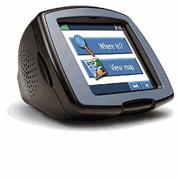
Garmin's StreetPilot c320/c330/c340> A Simplified Car Navigator
 .
.
c320 GPS unit
Daytime Map
Colors 3D View Mode
More
StreetPilot
c320
Photographs
The c3x0 screen is
a medium brightness
TFT daylight viewable-with-backlight screen. However, the c3x0
screen is not nearly as readable in bright sunlight as compared with
the SP26x0 models. c3x0 has no marine feature set and
no
hiking features are provided. The Lithium Ion
battery is sealed into the
package and is not normally user serviceable. HERE
are some comparative photos of the c320 screen with some
competitive models.
The features of the
c3x0 make it a fairly direct competitor to the Magellan
RoadMate 300 and to the TomTom GO.. A detailed comparison of
the features of the Quest, c3x0, and SP2610/2620 models can be found HERE. Our Magellan
RoadMate 500/700
review can be found HERE.
(Our review of the RM300 should be available in June 2005. The
StreetPilot 2610/2620 review can be found HERE.
As stated before, None of these units can provide the capabilities of a
full
featured
hiking and marine oriented handheld unit.There is a list of the major
features NOT present in the c320/c330 as compared to the StreetPilot
2610/2620 HERE.
Street priced at
about $600 or less, (Check
Latest Prices Here.)
the c320 is a medium priced Automatic Car Navigator..
Street Price of the C330 is about $800 or less.
While the c3x0 is not a full featured unit like the
SP2610/2620, it does provide guidance in the same class and
equally good maps with even the most expensive of todays car
navigators. The "non-technical user friendly" ease of use,
ease of map installation (and even no map installation at all on the
c330) make both units recommended for the non-technical user.
What about map loading and Map
Memory?
StreetPilot c320 uses a USB data interface
for
map loading and data input/output. But you CAN also load the maps even
faster on the c320 (only) if you remove the SD card and use an SD card
writer with your computer to load maps into the card. Map
selection, map build and download for a full 1 Gbyte SD card took
about 2 hours via the USB cable of which only about 15 minute was
"human
time" all up front. The c320 can be told to shut off at the end
of map loading if you wish. Also, while map downloading is
occurring, the C320 battery is being charged via the USB cable from
your computer. The c320
has no standard NMEA
input/output capability. The c320's furnished 128 megabyte SD map
memory will hold
approximately the states of Florida, Georgia and South Carolina with a
little of Tennessee thrown in. The 1Gbyte SD card held about
half the USA. In Europe, we find that the
c320's 128megs will
hold about half the UK or a bit less than half of France. You can
put part USA, part UK, and part France maps into the unit at the same
time if you wish. c320 comes with a routeable basemap for your
region just like VISTA/LEGEND COLOR (LC/VC), QUEST and StreetPilot
models.
Also
packaged in the c320 (only) Kit is the CitySelect Map system for the
USA and
Canada (or other region of the world for the area where you buy your
c320). The North American model c330 comes with a built in 2.2
Gbyte Hard Drive on
which
are preinstalled maps for all of the USA and Canada or for all of
Western Europe (European Models). Note1: Garmin will not
confirm the 2.2 Gigabyte size, that is Joe's guess.
Note2: As of May 2005, you can install other compatible Garmin
CitySelect Maps in the
c320 but not in the c330.
Note3: Garmin advises us
that coming production models of the c330 (as of about June 2005) will
have an SD Slot so that the user CAN load maps other than CitySelect6
on the c330.
With the Navteq brand maps, users will have the most detailed highway and residential street level GPS uploadable maps available for the USA today. The USA coverage area for furnished Navteq maps is the entire USA and ALL of Canada. c320 allows a user to automatically route using both the CitySelect maps and/or the Base Map. Thus, with a "routeable base map", you can automatically route from an address in New York City to San Francisco with only CitySelect map sections for NYC and SFO loaded. The base map will provide information (and "road lock") for all highway routing between metro areas. Garmin provides the only autorouting system that I am aware of that can do this sort of intercity routing without the need to load intermediate maps as you go from one Navteq region to another. Garmin is shipping the c330 with its new CitySelect 6 for the c320 map system preinstalled on a 2.2 GByte hard drive so no basemap is needed. (CitySelect automatic routing maps are only available for the USA, Europe, South Africa and Australia as of October 2004. However, Garmin Licensees are providing maps for a dozen (plus) other areas such as Chile, etc.) Check Garmin's Cartography site for a list of countries and vendors to contact. Note: Garmin tells us that AT THIS TIME the c330 can ONLY be equipped with USA/CANADA or European maps. Note: Jack and Joe recommend purchasing the c320, buying a US$75 one gigabyte SD card (or 2gigabyte when available) and load the states you need and enjoy a lower cost plus twice the battery life as compared with the c330. The added flexibility of being able to simultaneously load maps from parts of the USA/Canada, Europe, Australia, South Africa, parts of the Middle East and etc., give the c320 versatility not found in the more expensive c330 at this time.
This review was
done using copies of CitySelect 6
USA. With the supplied 128meg SD map memory you can load
detailed maps for a fairly large area. However, I suggest that at
least 512megs of map memory will be
needed by a great many people. Also, the
lack of a basemap can be frustrating if you take the unit
overseas as
(our) tours cover a lot of ground and this usually means that we have
to load maps several times if we only have 128megs of map memory.
We like Magellan's scheme
which offers basemaps for all parts of the world that can be loaded
into many of their GPS Car Navigator products. However, a 1GByte
SD card overcomes a lot of our objections as it is possible to load
about any maps you would ever need on a tour to one 1GB SD.
Note: There is no provision to load maps other than from one map
type (such as CS6) and then be able to switch between them as is
provided for on most other Garmin units.
Other maps compatible with
c320 include: CityNavigator (Navteq Maps, the best GPS routeable
maps available in areas covered), We understand that
Roads
&
Recreation, MapSource, USA Topo, and WorldMap CD ROMs also work with
c320, but
without automatic guidance. Probably most other Garmin maps will
load and operate, but Garmin supports only the maps that they
list as compatible in the c320 specifications.
Route Quality is rated "good" and in fact routinely gives routing the same as I would have chosen. Sometimes the route generated is just OK, but after all, these devices are just machines and they are operating without the local traffic knowledge an individual user has. The downside for c320 as compared to the $3000 models is that many of the more expensive models have some sort of "dead reckoning" capability to permit navigation to continue for short intervals when signals are lost. Such signal loss can happen in city canyons such as NYC, Chicago, LA, and London where high rise buildings can block the satellite signals. In fact, c320/2610/2620 do have "poor man's dead reckoning" in that when signal is lost, the GPS assumes you continued on your last heading and speed for up to 30 seconds. This 30 seconds covers most ordinary driving. The real dead reckoning capability is available in the Garmin StreetPilot 2650/2660 and in a few other units such as the VDO Dayton MS5000. The 2650/2660 will require a connection to the automobile speedometer output and backup light to be able to function in dead reckoning mode. Without these inputs, it will function same as the c320/2610/2620. Note: The 2650/2660 require connections to the speedometer and backup light signals.
The new c320 version of
CitySelect 6 provides "map chunks" in the form of the 50 states.
Selecting individual "map chunks" when
you want to load maps can take a bit of time.
MapSource has a new, though slightly hidden, feature to make this
EASY. With the map tool selected in CN6, simply hold
down your mouse button and drag to put a "box" around a specific area
of interest. Boxes can overlap and be various rectangle sizes
so you can use them multiple times in selecting your desired map
chunks. If you want to DEselect an area, hold the CTRL KEY
and simultaneously use your mouse to draw the box and you will deselect
any map chunks in the covered area. You can go to this
link and watch the MapSource tutorial, which will explain how the
new LARGE AREA map selection feature works.
Automatic ROUTE GENERATION with c3x0's high speed processor is quite fast. The calculation of a 400 mile route usually takes about 5 seconds. This compares to close to a minute with the SP-III. One trial route from Atlanta to an address in Maine took about 1.5 minutes with the SP-III and about 10 seconds with the c320 which seems extremely fast by comparison. Off Route, reroute recalculation with the c320 typically takes a few seconds and it generally tries to take you back as quickly as possible to your ORIGINAL route.
The c3x0 models do NOT offer the
capability to create a route on the PC and download it to your GPS for
execution. You can create waypoints and download these to your
c3x0 for use as destination waypoints. There is no provision in
the c3x0 for VIA waypoints as are available in Garmin's other Car
Navigators..
Note: As of this date, NO OTHER map products (from alternative vendors) can be uploaded into Garmin GPS receivers except those offered by Garmin and Garmin LICENSEES for the purpose. (See Garmin Website's Cartography section for a full list of map offerings.) This same proprietary relationship exists for other vendor's consumer GPS products as well.
What's new in the c3x0 models?
The c320 kit contains: GPS with speaker built into the unit, power cable, USB data cable (for memory and data load and Garmin Data Protocol output), suction cup Dash Mount Bracket, AC power module for use in loading memory, CitySelect 6 CDROM, and Manual. The c330 is the same but without the CitySelect CDs because map software comes fully loaded and ready to go in the c330.
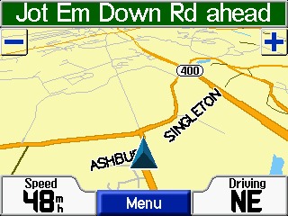
Like all modern car navigators, c320 gets rid of almost ALL of the bad effects of GPS measurement error that bother many people. When you use CitySelect, the c3x0 will "lock" your vehicle track to roads as long as you travel on the road. This feature does not operate with MapSource R&R, USA Topo, or WorldMap among others. Automatically generated routes using CitySelect or CityNavigator maps "rubber band" to the roads in the route. Once in a great while, you may find an isolated road segment where the map is so far off that road lock will jump off the road, but it is rare.
Another useful
feature with
CS/CN maps is that (when not in
guidance mode) all
approaching cross street names are displayed prior to
arrival.
We
found the audio and visual guidance directions very
satisfactory. c3x0 automatically varies its
"turn here" warning time to give you more warning time at
high speed than at lower speed. A typical audio/visual sequence
would go something like this:
=================================================================
Another screen display is the trip computer. Data displayed include: Direction of travel, current speed, miles to go on route, miles traveled, overall average speed, moving average speed, maximum speed, total time, moving time, and stopped time. There are no user adjustable data fields on the trip computer screen or elsewhere in the c3x0 units.
Another available screen is the written description of "next turns". This is accessed by pressing at the top of the touchscreen on the legend showing the current street being traveled.
AUTOZOOM zooms the screen in and out automatically as you approach turns so you have time to make decisions.
Route selections for CAR/Motorcycle, Bus, Truck, or Taxi, or Emergency vehicles are provided so you can be properly routed depending on your vehicle type.
CitySelect now features about five million "points of interest" in the USA. These include: Food and drink, Lodging, Attractions, Entertainment, Shopping, Services, Transportation, and Emergency and Government. In our area, there were a few restaurants we had not known about and a few prominent ones are missing. Likely this will always be the case. Despite some obvious updates and additions, the restaurant listing appears to be about 2 or more years old. Listed "Attractions" include theme parks, museums, schools, parks and such. The listings were quite satisfactory though the placement of a particular restaurant or gas station might vary plus or minus a few hundred feet (once, half a mile) from the actual location. This feature could be very handy in a strange city. Do not be overly surprised at imperfections such as your favorite restaurant being missing or some restaurant that is out of business for 5 years still being in the POI list. The POIs come from a multitude of data sources and it is simply impossible to insure accuracy with the resources available for the task.
The user can give
the GPS a Street Address
or Street Intersection or select one of the, for
instance, Restaurants in the accessory map data base
module and it will LOCATE this address or location automatically
and plot it on the map screen. The c3x0 can then
automatically create a "turn-by-turn" route to this destination from
wherever you are. This is a very useful feature and it has worked
very well in our tests. Be prepared for a few well known items
(such as my local library) to be missing from the "attractions"
list. Still, if you are unfamiliar with an area, what
IS included will be quite useful.
Are the 128
megabytes of SD card MAP MEMORY enough?
The "comes with the
kit" 128meg SD map memory will be enough for many users.
The fact that the full USA coverage
basemap can be used for navigation on interstates and major roads and
highways mitigates the need for full coverage of the high detail maps--
but... Personally we do like to have the full detail maps loaded just
in case we need services or a good restaurant while on the interstate
highway. Still, if you rarely travel more than your own
state plus one to four other nearby states, (on average), c320's 128
megs of
SD
map memory will get you there just fine.
When
you need complete detail for a PARTICULAR city or rural
area you are going to visit, you can load from your laptop, or
other IBM type Personal Computer, high detail maps from
CitySelect 6 into the memory using the furnished USB
cable. Note that with the c320's special version of CS6,
you MUST load a full state map at one time. You cannot load
smaller map sections as you can with the standard CS6 (MAC users
note: Users report mixed results trying
to load Garmin maps using a MAC. Count on needing a PC to load
maps on
the c320 to
avoid disappointment.)
The
basemaps in the c320/c330 do not allow the user to route to anywhere ON
the basemap. However, if
you are going from, say, Chicago to San Francisco and
back to Miami with a stop in Denver, you might load detailed maps
for the four urban areas of interest and let the basemap be your guide
THROUGH other areas and still have lots of empty memory in your user
map
cartridge for other areas. The unit automatically transitions
from the basemap to the detailed maps when the detailed maps are
available and back again as you move out of the detailed map
areas. While it is quite easy to load new maps from a laptop
computer into your c320, having a basemap for the entire USA and
Canada that will route you between towns and cities can eliminate the
need to load highly detailed maps for intercity travel. That said, DO
NOT
expect that the basemap is as accurate as the CityNavigator maps from
Navteq. There will be some areas where the map error is larger
than 150ft and the c320 will think you are offroute and will
recalculate. This is a minor irritation for some people but
if you just ignore the problem when it rarely occurs, things
work out fine.
What are the Technical Specifications of the c320/c330?
Specific Questions Answered:
We do not recommend c320 for hiking or marine activities due to its reduced feature set optimized strictly for automobile use.
The c320 used for this review includes no basemaps outside the Northern part of the Western Hemisphere. The basemap of North America includes maps of USA interstate, national, primary and secondary state highways, cities, larger towns, waterways, rivers, and coastlines and high population parts of Canada and Mexico. (Note: See Garmin Base Maps description for more information on Base Map content.) Base Maps are included in the c320 's internal memory while USER Uploadable Street Maps on CD ROM provide street level or topo detail of user selected areas which are loaded to the 128meg to 2048meg (2GByte) SD memory cartridges. Garmin (unlike some Magellan models) provides no capabilities for the user to change from one basemap to another.
Additional
features
include:
The trip computer works similarly to other late model car navigators. With c3x0, you will notice that when you come to a stop, the estimated times do not go to infinity, but hold a realistic value. The GPS calculates estimated times based upon road classes in your Route and modifies the estimation by your actual speeds on the various road classes. It also computes the actual road distance between turns (waypoints) instead of using straight line distances. The results give fairly accurate estimated time to various points, even when using different road classes, like traveling on the freeway, and then exiting later on some local roads. Your estimates will not only be based upon your current highway speed, but by the combination of speeds you are using, or will be using on the various road classes. We note that the arrival time was within 10 minutes on one 400 mile highway drive we made after it "learned" our driving speed habits. Usually it slightly underestimates the time principally as a result of unexpected traffic congestion which randomly occurs.
The GPS has the standard HOST mode which allows the upload/download of waypoints only. The external power/data cable is different from other Garmin GPS equipment including StreetPilot models. However, the unit charges when connected to a laptop or other active USB port It is doubtful that as of October 2004 any third party software is available to interconnect with Garmin's USB data port on the c3x0 and it would not be very useful if available..
The
data fields, on the main display screens ARE NOT user
configurable on the c3x0 models.
CityNavigator's Find-an-Address feature includes: Recent Finds, Cities, Exits, Addresses, Intersections, Points of Interest, Food, Lodging, Services, Entertainment, Attractions, Shopping, Transportation, Emergency and Government and Waypoints. However, some of the locations of restaurants, hotels, etc. are misplaced by considerable distances. Since the data is at least a year old, some businesses are "missing" but overall the data is quite accurate and useful.
When not
routing, a "Driving Status"
line on the top of the Map display indicates such
information as "Driving South on Roswell Road".
This can be quite useful in cities where you don't
exactly know which street you are on. Also as you are driving, the name
of each approaching side street is displayed allowing finding side
streets in the dark.
Brightness
on the c3x0 does NOT automatically adjust for ambient light
conditions
like the SP26xx models. However, automatic changeover from night
to day mode as needed is provided.
Datums- The c3x0 supports the standard WGS-84 datum only.
User ICONS are NOT supported in the c3x0.
The price of the c320 includes: GPS unit, power
cable, CitySelect 6 CDROM (full USA/Canada license), Suction cup mobile
mount, USB data interface cable, AC 12vdc
PSU and cradle for auto use, manual, quick reference
guide and other documentation.
The c3x0 operates from external power in the range of 11 to 24 volts DC or from its internal LiOn battery. Battery life on our c320 unit was about 6 hours. The LED backlit display lighting has a rated design life of 100,000 hours. The c3x0 shuts down when power is removed and turns back ON when external power is restored. (Assuming the power was ON when the external power failed.)
A special mobile power cable is supplied with c3x0 . The power cable used is NOT the same as any prior Garmin cable connector. You will need the (industry standard) USB DATA cable (furnished) to load maps into your and/or to upload/download routes/waypoints/tracks to your personal computer.
The external antenna connector, a MCX coax jack, is located on the right rear of the unit. The MCX jack is powered (nominal 2.7 volts no load in our unit) and has a current limit rated at 25 ma to protect the unit from shorts on the antenna cable. The normal antenna is built inside the unit and is not removable. The Garmin GA-27C (Garmin part number 010-10052-05) amplified antenna, some from Tri-M, and other 2.7 volt rated antennas work with the c3x0. We believe most 3 volt antennas will work as well.
The c320 does not support NMEA-0183, DHCP or RTCM. Garmin has included an abbreviated version of its standard HOST MODE and no other option.
The maximum altitude rating is 60,000ft and speed maximum is 999 knots.
Subjective Observations of PerformanceI have tested
the c320 on roads
and highways of North Georgia and Atlanta including several
interstate trips. We used CS6 for our tests.
Our c320 has worked properly almost all the time in our tests.
Only twice in about 1500 miles of driving, the unit gave faulty turn
directions. In these instances, our SP2610 (running
simultaneously) did not err. Generally,
tracking worked well but as is normal, we occasionally lost lock
momentarily in cities and in deep mountain valleys.
There was never a failure to lock to SVs in a reasonable time which was usually about 15 seconds.
The SP performed on a par with other GPS units in every test for lock stability, multipath performance, re-lock after an underpass, and ability to suddenly change direction without loss of lock.
We note that all Garmin GPS models including the c320 have a form of "dead reckoning" for moments when signal dropouts occur. For instance, if the is tracking along and just before a sharp turn you invert it and block its antenna, it will continue to track straight for about 30 seconds. It also provides a very good data smoothing filter to throw out random fixes that are way off track. This results in an exceptionally smooth track on a moving map display. Even with this filter, there was no overshoot apparent during quick stops, sharp turns, and similar maneuvers when normal continuous tracking was taking place.
c3x0 performance under tree cover and city canyon conditions was about the same as the earlier SPs, G-V, G-II+, G-12XL, and we rate that as very good.
We found the display controls exceptionally easy to learn and use. The overall system is suitable for car navigator use by users not familiar with computers and computer technology. This is especially true of the c330 which comes with maps already loaded. What the average user has to work with on a day-by-day basis is very simple to understand and manipulate. The menu system and arrangement is generally quite intuitive and easy to learn to use.
Since the c3x0 exhibited essentially identical tracking performance with other Garmin units in our tests, we did not perform the extensive field trials we made with the G-12XL, EE, and others. For more information on tracking results with our testing of the G-12XL, and the G-II+, etc., see our reviews at: http://gpsinformation.net
Summary
Our overall impressions are that the is Garmin's version of a low cost Automobile Navigation System with limited feature set but with exceptional ease of use. We consider the c3x0 to be "very good" in the low price class of Car Navigators. (Check Latest Prices Here.) We think the is a good product for the money.
*Problems
and Quirks noted in using
the c320
1) The map display readability is the worst
problem of the c3x0. The road on which the route is moving is
displayed clearly. However, cross streets and nearby streets are
shown on the routing map with such low contrast as to be unreadable in
bright sunlight. In fact, the entire display becomes extremely
difficult to read in bright sunlight in all the c3x0 models.
Garmin has indicated no plans to upgrade the display on these
models. (Note: The C5xx models DO NOT have this problem and in
fact have a much brigher and more readable display.) We find that named
cross streets and nearby
streets and landmarks to be extremely useful in showing exactly where
you are at a given time. We sorely missed this ability on the
c320.
2) As with other Garmin Car Navigators, entering street
names can be
a problem. You might know a street name as AC Lewis Road, or A C
Lewis Road or Baywater or Bay Water or
Baewater or Arbor vitae or Arborvitae and the spelling may/may not
match the
local convention. The user MUST spell it like the
Garmin/Navteq
database or the address cannot be found. This can lead to not
being able to find a street that you know is there. Navteq
tells us that their convention is to run
initials together and use caps, so you might try that if you get
stumped with a street name with initials. For a street address
with a highway number, try just the number such as 32 (not HWY32).
3)
We sorely miss the INability of the c320 to allow the user to select
display parameters from a list as in other Garmin models.
However, the c3x0 units are intended for a "low tech", unsophisticated
customer and the design goal was to keep the user interface to that
absolutely essential for car navigation.
4) POI
groups are incomplete (though they are VERY VERY helpful).
As examples: I find that
some post offices and libraries in my local area are not included, but
MOST are. I am afraid relief here will be forever in coming.
5)
On occasion, we see the router
generate "funny routes" such as taking a busy numbered federal highway
instead of a nearby freeway.
Overall, the performs
as well as other Car Navigators we have used. Garmin
tells me that these problems WILL be looked at if users will go to http://www.garmin.com/cartography/mapSource/errorForm.html
and fill out the report form. Lets ALL do
it! Overall, I must say that every edition is
better than the one before as to routing problems.
6) The c3x0 uses a slightly different algorithm for navigation
than the SP26x0 models. At times, I found the display and audio
combination directions to be confusing and even misleading. On a
trip of about 1500 miles, on at least four occasions (in the dark each
time) the instructions were misleading (or unclear) enough for me to
make a wrong turn. The 2610 running at the same intersection
provided substantially easier to interpret instructions.
After switching to the SP2610 unit in the dark on this trip, I missed
no more complex turns.
Which GPS do I like to use when I go on automobile trips? The StreetPilot 2610/2620. I must add that the c3x0 is a great unit when small size and lower cost are part of the equation. It seems ideal for the person who is "computer hostile"... That said, I personally prefer the SP26x0 units because of their MUCH more capable and flexible feature set and because of their much more readable display screen.
If anyone has any additions, ions, suggestions, error corrections other comments, please feel free to Email.