These Venders support The GPS INFORMATION WEBSITE. Click on BANNER to check PRICES.
Garmin's StreetPilot
2720 TouchScreen Car Navigator
GPS Product Review
by
Joe Mehaffey
Release 3
updated, 24 September 2005
(Note: New revisions in RED
type)
 .
.
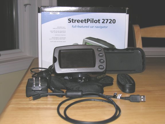
StreetPilot 2720 Kit
Daytime
Map Colors
(NOTE
that the actual size of
the screen images is 3.8 x 1.8 inches.)
More
StreetPilot Photographs>
(Note: This photo image file size is 2.5 megabytes in size.)
The
Garmin StreetPilot 2720 is in
Garmin's latest generation of GPS receivers with street level
mapping and automatic route navigation for your car. This new offering
has an optional GTM 10 RDS Traffic Radio Data receiver. With
this
option, the user can be automatically advised and rerouted if
congestion occurs on your programmed route in covered metro areas.
Another feature is the ability to upload CUSTOM Point of
Interest
(POI) points such as speed camera locations, red light cameras, or
other interesting landmarks. An optional proximity alert can
warn
when approaching a custom POI.
Like the
StreetPilot 26x0 series, the SP2720 features a TOUCH SCREEN for data
input and control -and- map
storage comes loaded with CityNavigator maps for the USA and
Canada -and- it also has a USB data interface for
map loading and data input/output. The memory map memory in the SP2720
is Flash RAM. 750 megabytes of additional memory is
available for other
user loadable maps. Like the SP26X0) models, the SP2720 has
implemented a
solution to "the traveling salesman
problem". The user can input a series of destinations and the
SP2720 will compute a "shortest route" to cover all of the locations in
a minimum time or minimum distance trip.
The 2720
is similar in appearance to the SP26X0 series but without removable
memory feature. Note:
Later production models of the SP2620 have been changed and do not have
removable media same as the SP2720.
The GPS
antenna is integral within the unit and the unit is
designed to fit on top of
your dash and provide visual and audio directions for
navigating your car on unfamiliar streets and roads.
A
battery powered IR remote
control is provided so that passengers can program the unit even from
the back seat. Functions of the SP2720 are operable from
both the main unit and
the remote, but many features are more easily operated by the remote
control unit.
Unfortunately (for the kids),
Garmin did not
choose to put any games in this model.
We
think the
StreetPilot 2720 has a good user interface but not quite as
nice as the SP2610/20/50/60 series. There are four push
buttons for major functions (PAGE, MENU, FIND, and
SPEAK/volume. (Only the SPEAK key retains the dual function capability
found in the SP26X0 units. We particularly miss the ability
to
easily MARK a location with a waypoint by pressing and holding a
key.) Like the
SP-2610/2620, the 2720 is designed without internal batteries and
operates
ONLY when plugged into an external 10 to 24vdc power source.
Like the SP2610/2620, the SP2720 automatically turns ON
and
OFF with the power application from its external power cord. A switch
is provided to turn the unit on and off manually as desired.
Unlike the SP26X0 series, the screen does not time out to the map
screen automatically. The
SP2720 was designed to replace
the
combination of GPS/Laptop Computer/Mapping
Software system that many still use to maneuver around cities
in
the
USA.
Here
is a
comparison
note with respect to the Magellan RoadMate 500/700/760 which is the
direct
competitor of the SP2720/2610/2620. Both vendor's units have
plusses and minuses
with
respect to features. The Magellan 500/700 is THE simplest to
use
of
any car navigator we have reviewed. Many car navigator units now offer
complete USA and Canada maps already loaded "right out of the box"
SP2720 continues that welcome feature addition. On
the
other
hand, the Magellan 500/700 systems have far fewer "normal GPS
features" as compared with the
SP2720 and 26xx series. The SP series has slightly better
guidance
information in complex expressway interchanges
Which one is
"best"
depends 100% on your needs and on your interpretation of what features
are "essential". In this review, we will describe
the
rich feature set of the SP2720 unit. Our Magellan RoadMate
review can be found HERE.
Street
priced at
discount GPS dealers for
about $895 and less, (Can be bought for up to $1000 and up), (Check
Latest Prices Here.)
the SP-2720 is a medium priced Automatic Car Navigator -and- One of the
best
performers. The 2720 is perhaps $100 more than the SP2620
model
which also comes out-of-the-box with complete USA and Canada maps
installed.
With
the SP-2720
you do NOT receive a copy of the NavTeq CityNavigator 7 CD.
(Note: This
is being changed soon and you WILL receive a version of firmware and
the necessary CD software to allow route creation on the PC and
download to the SP2720. My review unit does not have this
feature.) Instead, the maps come already loaded
in internal Flash Memory.
(CityNavigator
automatic routing maps are only
available for the USA, Europe, South Africa, and Australia as of August
2005). The CN7 in the SP2720 is "permanent" and
not
erasable by the user to use for loading other maps. However,
these "permanent" maps can be updated/upgraded with newer CityNavigator
maps in years to come as Garmin provides ongoing updates..
In addition to the fixed USA/Canada map memory,
there
are 750megabytes of additional "user map memory" into which you can
load
maps from Europe or other parts of the world -OR- you can load USA Topo
maps from Garmin or other Garmin furnished maps. Note: Garmin does
NOT recommend Topo Maps for use with the SP2720.
The concept of a
"base map" for the USA is
not relevant to the SP2720 as it has complete USA maps installed when
purchased in the USA. Or if purchased in (say) Europe, it
will
have complete European maps (see Garmin website for coverage
information). For loading CityNavigator maps into user memory
for
areas OTHER THAN those included with your GPS, as a rough planning
guide for
calculating storage card capacity is: 4 megabyte
for
every million
population. The 750 megabytes of user map storage is thus
able to
store large areas of Europe, Australia, and/or South Africa using
Gamin's
available overseas map products. As
to CityNavigator map sizes,
the
four central Atlanta "map chunks" are about 1.5 megabytes each, and
other area "map chunks" range from 400 kbytes to 2.0 mbytes. To see
EXACTLY what CityNavigator maps look like for YOUR area, click HERE
and
select CityNavigator on the map viewer. Keep clicking on the
map until you get your area in whatever detail you want. You
can route to covered highway intersections just using the
basemap.
The
StreetPilot 2720 is straightforward to use, and the manual is a bit
better than average. Still, there is no substitute
for a
few
hours of "playing around" with the unit in consort with the
manual for quick learning and
discovery of available features.
The SP-2720
routinely gives routing
"the same as
I would have chosen". I will say that in our testing, the SP2620
model
with CN7 at odd times would give a superior route as compared to the
newer SP2720. I attribute this to the fact that the SP2720
uses a
new
algorithm which is different from that used on the older
SP26X0
series.
I believe that as a result, the SP2720 fails to consider as
many
alternative routing options as are considered by the algorithm used in
the SP26X0 units. I place the routing proficiency of the
SP2720
on
a par with "industry norms" but with the routing ability of the SP26x0
slightly
superior. Sometimes the route generated
is "just
OK", but... the SP-2720 is just a machine. (Note: If you will be upset
when a GPS Car Navigator fails to generate precisely the route YOU
would have picked, then expect to be disappointed from time to time.
The SP2720 routes generally very well, but not exactly as a
human
would.)
Automatic
ROUTE GENERATION with SP-2720 is about average for a GPS Car
Navigator. There is no "Quick, Better, Best" route selection
on
the 2720 as on the 26X0 models. On the calculation of a 400
mile
route, the 2720 usually takes about 15
to 20 seconds. This compares to close to a minute with the
SP-III and to 5 to 10 seconds on a 2620.. One trial route
from
Atlanta to an
address in Los Angeles took about 2 minutes with the SP-III and 20
seconds with the SP-2610/2620 and SP2720 which seems
extremely
fast by
comparison. Offroute, reroute recalculation with the new
"Partial
Reroute" algorithm typically takes about 1 second and it (generally)
tries to take you back as quickly as possible to your ORIGINAL
route. It does this the first THREE times it goes
"off
route, recalculating". On the fourth "off route" it figures
out
you are serious about not going back to the original route and does a
complete recalculate which on a local (25 mile) route usually takes
just a few seconds. (SP-III ver 2.50 is using this same
algorithm
and it seems to be confusing some folks, but I personally like the
rerouting
speed so much I am willing to put up with the first three reroutes not
necessarily taking you the optimum route. If you do not like
the
"partial reroute" offered by the SP2720, you can always press the
FIND key, then RECENT FINDS and then select your address
again
and press GOTO. I note here that this is more than twice as
complex as the same function on the SP26X0 units. I have also
found that when the SP2620 us set to "better" or "best" routes, it
often generates superior quality routes as compared with the
SP2720. )
The
early version of SP2720 offers no capability to generate maps on the PC
and download
such a route to the GPS. Software available about 10 Sept
2005 now offers this feature.
Frankly, using PC for routing is NOT what you would normally
want
to do with the
SP-2720 in any case. It is much easier and more convenient to
use
the SP2720 itself to generate and mold the route to your needs as
compared with
generating routes on the PC and then
having to download routes to the GPS navigator. The
CityNavigator (NavTeq) maps offer
coverage the entire USA and major metro Canada as well.
Details
in rural Canada are not complete, but are much better than in CN5.
Details as to which lane to be in and which way to turn onto exit ramps
at complex expressway interchanges is frequently included.
The
SP-2720/2610/2620 uses
a USB connection for data loading.
NMEA
data I/O
is NOT available on the SP-2720.
Note:
As of this
date, NO OTHER map products (from alternative vendors) can be
uploaded into Garmin GPS receivers except those offered by Garmin for
the purpose. This same proprietary relationship exists for other
vendor's consumer GPS products as well.
This
new
SP-2720 is designed principally
for
automobile use and its size, the high power drain, absence of
an
internal battery, and
lack of off road or marine features make it unsuitable for hiking or
boating
use. It does have an OFFROAD mode that can be used to
advantage if TOPO maps are loaded.
What's
new in StreetPilot
2720?
The
SP-2720
kit contains: SP-2720
GPS, Speaker/power cable, USB data cable (for memory
and
data load and Garmin
HOST MODE data output), Dash Mount Bracket, "bean bag"
portable
mount, AC power module for use in loading memory,
and
CityNavigator 7 comes already installed in the 2720. Also
included are a quick start guide, detailed manual, and a plastic cover
for the faceplate.
The
SP-2720
gets rid of most effects of GPS measurement error that bothered many
people in years past. CityNavigator 7
will "lock" your vehicle track to roads as long as
you travel on the road. (This feature does not
operate with
MapSource R&R, USA Topo, or
WorldMap.) Automatically generated routes using CityNavigator maps
"rubber band" to the roads in the route. Once in a great
while, you may find an isolated road segment where the map is so
far off that road lock will jump off the road, but it is
rare.
Another
useful
feature with
CityNavigator is that all
approaching cross street names are displayed prior to
arrival.
We
found the SP-2720 audio and visual guidance directions very
satisfactory but the voice was not quite as understandable as with the
SP-2610/2620.
This was especially noticable in the pronunciation of odd
street
names. The SP2720 uses a text-to-speech technology for voice
generation
and there is some "distortion" in the pronunciation of many street
names and town names. But, all in all, it works
satisfactorily.
The voice
guidance system automatically varies its
"turn here" warning time to give you more warning time at
high speed than at lower speed. We are told that
Garmin
will offer a website download for the following languages:
American English, Australian, and British English, French,
German, Italian, Spanish, and Dutch. A typical audio/visual
sequence
would go something like this:
- <audio> In
1.5 miles exit right.
<screen> shows arrow to the right, distance to
go, speed, time to go and "Exit right to I-285 West"..
- <audio> In
.3 miles exit
right. <screen> shows Exit Right to I-285.
- <audio> In
1.2 miles exit right
<screen> shows Exit Right to Roswell Road NE
- <audio> In
.3 miles exit
right. <screen> shows Exit Right to Roswell Road NE.
- <audio> In
800 feet turn
left. <screen> shows Turn Left on Roswell Road NE.
- <audio> In
1.2 miles turn right.
<screen> shows Turn Right on Mt. Paran Road NE.
- <audio>
drive .3 miles to
destination <screen shows .3 miles to destination.
- <audio>
drive .1 miles to
destination on right. <screen> shows .1 miles and the
destination
waypoint/address.
- <audio>
destination 500 feet
ahead on right. <screen shows destination waypoint/address.
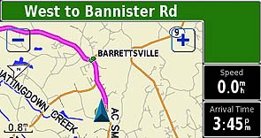
There
are some options in guidance display for the SP2720. The one
I
like has the map on the left half
of the screen which shows your progress and a thick pink line shows
your
projected route on the map. On the right is the text information:
speed, time to go to next turn, distance to go to next turn
and written directions/information as needed. At any time, you can
press the "speak" key and get the latest directions in audio
form. The text information display on the right can be varied
using several fixed options which can be suer selected. See
screen image photo page for details. Unlike the SP26X0
features,
the size of the text information display
cannot be user adjusted on the SP2720.
An
alternative
"turn list" screen shows a listing of
turns to come. Another screen display is the trip computer which is
accessed at any time by pressing one of the numeric displays on the map
screen. Data displayed on the trip computer screen
is fixed
and not user selectable.
AUTOZOOM
zooms the
screen
in and out automatically as you approach waypoints and turns so you
always have time to make
decisions. A blue pop up arrow on the left side shows
distance to
go and direction of the turn as you approach a turn. I
generally found the route turn advice timely and not confusing.
Route
selections
for CAR
or TRUCK or BUS, Motorcycle,
Taxi, Delivery Vehicles, Bicycle,
Pedestrian, or EMERGENCY
vehicles are provided
so you can be
properly routed depending on your
vehicle type.
CityNavigator7
(USA) now features
about seven million (USA) "points of interest" on board.
These
include: Food
and drink, Lodging, Attractions, Entertainment, Shopping, Services,
Transportation, and Emergency and Government. In our area,
there
were a few restaurants we
had not known about and a few
prominent ones are missing. Despite some obvious
updates
and additions, the
restaurant listing (still) appears to be about 2 years old. One of my
favorite restaurants (Longstreet's/Gainesville, Ga.) is not
listed despite being in
business for more than 25 years. Even so, the listings are
large,
varied and very useful.
Listed "Attractions" include theme parks, museums, schools, parks and
such. The listings were quite satisfactory
though the placement of a particular restaurant or
gas station might vary plus or minus a few hundred
feet
(once, half a
mile) from the actual location.
This feature is very handy in a strange city on on the highway.
The
user can give
the GPS a Street Address
or Street Intersection or select one of the, for
instance, Restaurants in the accessory map data base
module and it will LOCATE this address or location automatically
and plot it on the map screen. The SP-2720 can then
automatically create a "turn-by-turn" route to this destination from
wherever you are. This is a very useful feature and it has worked
very well in our tests and on trips we have made. That said,
the
classifications and selection process used in the SP26x0 models has
proved more reliable at finding items in the "attractions" listings.
Be prepared for a few well known items
(such as my local library) to be missing from the "attractions"
list. Still, if you are unfamiliar with an area, what
IS included will be quite useful.
What
are the Technical
Specifications of the SP-2720?
- Waypoints: 2000 with (up to) 20 character name
and
graphic symbol
(Autorouting does not use these waypoints.) Autonumbers each
waypoint but allows users to change waypoint name using remote control
or touch screen. Note: SP2720 has NO capability to
MARK a
waypoint using a single button as in most other units. We
consider this a significant limitation.
- Track log: 2000 track log points
- Routes: Up to 50 routes
with multiple VIA points may be saved for recall.
- Trip Information Page: Speedometer, Resettable
odometer and trip odometer,
Compass Indication, moving time, stopped time, total
time, average and
maximum speeds
- GPS
Receiver: 12 parallel channel GPS
receiver continuously tracks and uses up to 12 satellites.
(WAAS
is available in these models.)
- Acquisition times: Warm: Approximately 15
seconds, Cold: Approximately 45 seconds, AutoLocate:
Approximately 2 minutes
- Update rate: 1/second, continuous
- Position Accuracy: Position: < 15 meters (49feet),
95%
typical with
clear sky view and good DOP, claim 3 meter accuracy (95% confidence)
with WAAS.
- Velocity accuracy: 0.05 meter/sec (.035mph) steady state
- Dynamics: 6g’s
- Interfaces:
USB (ver 1.1) (No RS232 serial port.)
- Antenna: Built in patch type GPS antenna with external
MCX-type connector
jack. Accepts external amplified antenna.
- Physical Size: 3.2"H x 5.6"W x 2.0"D (8.0 x 14.3 x 5.0
cm) (Same Size as the SP26X0
units.)
- Weight: .93 pounds (420 g) (Same as 26X0 units.)
- Display: Finger Touch Screen, 3.8”
x 1.8" WQVGA (262k colors); 454 x 240 pixels; bright,
automotive-grade color TFT with automatic dimming backlight and touch
screen (More
resolution than the SP26x0 models and wider. )
- Case: Rugged; fully gasketed to IPX-7 waterproof.
Remote control NOT waterproof.
- Temp. range: 5°F to 158°F
(–15°C to 70°C)
- Data storage: Indefinite; no memory battery
required
- Map storage: No map Data cards used. Map storage
is on internal, non user removable, Flash Memory.
- The SP-2720 uploads
MapSource maps
at up to 12mbit/sec using the USB 1.1 port. Your
throughput
will be less than this theoretical maximum speed.
- Routes: Up to 50 routes
with multiple VIA points may be saved for recall.
- Trip Information Page: Speedometer, Resettable
odometer,
Compass Ribbon (moving), time of day, driving time, stopped time, total
time, Multiple Mileage Logs, average and
maximum speed.
- GPS
Receiver: 12 parallel channel GPS
receiver continuously tracks and uses up to 12 satellites.
(WAAS
is now available in these models as a result of a Spring 2004 software
update.)
- Acquisition times: Warm: Approximately 15
seconds, Cold: Approximately 45 seconds, AutoLocate:
Approximately 2 minutes
- Update rate: 1/second, continuous
Specific Questions Answered:
- Does the SP-2720 have
automatic daylight
savings time? Yes, it works in the USA (only). Daylight
saving
time rules in most of the rest of the world are too
"flexible" to
make it practical to include other areas at this time. The
unit
does NOT have automatic time change when moving between time zones.
- What is the battery
life? These
models operate ONLY from an external source of 10 to 24vdc and
have no internal batteries. Maximum power draw from a 13.8
volt source is 12 watts or about 1 amp.
- Is
the color screen viewable in
sunlight? Yes. We think the 2720 and the 26X0 models have the
best screen for
viewing in the car that we have seen. Naturally, Direct
sunlight
washes it out a bit, but if it is in
your car on the dash, it is quite satisfactory in all conditions we
tested it in. This unit has no contrast control and does not need one
in our opinion.
- What
memory cartridges can I use with the SP2720? None.
No
memory cartridge capability is provided. There is a fixed 750
meg
of internal Flash Memory available for additional user maps beyond the
CityNavigator 7 maps provided. CN7 maps ARE NOT erased when
you
load additional maps.
- Does SP-2720 have a trip
computer? Yes, but with fewer features than the SP26X0 units.
- Is the SP-2720 the same
size as the
SP-26X0 units? Yes It is the same size and shape,
but the screen size is larger. It
uses the same mounts and antenna connector, power
connector and data connector and has no batteries.
- Where
is the speaker for the audio
output? It is mounted on the power cable near the 12vdc power plug
(car end). The audio output comes from the same connector as
the power input. There are no external connector
pins for
external audio output. Motorcyclists and others who want to
tie
the SP2720 into their vehicle audio system will have to open the
speaker case and bring out the two speaker wires -or- break into the
speaker-to-GPS cable. ANY MODS SUCH AS DESCRIBED WILL
TERMINATE
YOUR WARRANTY. The speaker wires in the cable are the brown
and
white pair and they are "push pull" and neither should be referenced to
ground or noise pickup can result. The voltage across the
speaker
wires is about 2.5v peak-to-peak at normal volume. I
recommend
you locate a small 1:1 audio coupling transformer and use it to couple
into your motorcycle audio system. Radio Shack is one source
of
such transformers. NEEDLESS TO SAY, making any such
change
as this voids the warranty and if you cause any damage,
Garmin is
not likely to look favorably on a warranty repair for your
unit!
AND.. If you do not PRECISELY understand what is stated
above,
don't attempt this modification! Garmin now offers a Motorcycle
Mount Kit which is available with audio cables.
- Is there
enough audio volume available
to use SP-2720 in a noisy truck? In a <normal> car, we
judge the volume will always be ample. Audio is fine in a Ford
F-150 truck and we think it will work OK for a fairly noisy truck as
well, but you can always connect an external audio amp and speaker
or even earphones (will require opening the speaker case and voiding
the warranty and perhaps some additional connector/hardware).
- Is the audio clear and
easy to
understand? Yes. We think the audio quality of the female
voice is "generally" quite clear and understandable. This unit uses
text-to-speech technology and this is not as clear and refined as in
other Garmin units such as the SP26x0 models. My test unit
only
supports English, but there is a Language option.
- Is there a MUTE switch
for the audio?
Answer: No. There is a volume control that you reach by
holding the SPEAK key down.
- Are the contrast and
brightness
adjustable? Brightness is, but there is no contrast control (and none
is needed). There are about 10 brightness steps.
The
available
viewing angle of this new display is slightly more than in the SP26X0
units AND the viewing angle is skewed so it favors the left (driver
side in the US). Both the driver and passenger can usually
view
the screen at the
same time (if the unit is placed in the middle of the dash and forward).
- Is
CityNavigator included? Yes. CN7 comes preinstalled and ready
to go out of the box.
- Will my old SP (or
SP-III) cable work
with SP-2610/2620/2720? No. The connectors are different and
a new
speaker/power cable comes with SP-2720.
- How
do I load additional map data in a
reasonable time? Using the USB cable is the only way to do it.
Use a computer with USB-2 capability for fastest loading.
- Does SP-2720 come with a
dash
mount? Yes. Similar to the older SP-III mount with the same
mounting foot. Also included is a portable "bean bag" type
friction mount for use in rental cars or where a fixed mount is not
desirable. The portable mount seems pretty secure.
- Can I upload/download
waypoints/routes/tracks to the SP-2720? Yes, with the latest
SP2720 firmware you can download all three.
Third party applications such as G7ToWin and others will require I/O
protocol update for compatibility.
- Is <my>
street shown on the new
CityNavigator maps? Garmin now has their MapViewer
working with CityNavigator shortly so you can check for your area.
- If I deviate from the
calculated
route, what happens? SP-2720 can be set to automatically
recalculate a new
route to your destination without operator intervention.
- Can
I "TrackBack" on a tracklog with SP-2720? No. This feature is not
supported. Instead, you would use
AUTOROUTE and enter the destination address.
- How
many waypoints can be in an automatically generated route? I am not
sure. I have tried cross continent routes from Atlanta to Los
Angeles and they work fine. Waypoints created by automatic
routing do not reduce the 2000-available user waypoints. User
waypoints can be used to initiate an automatic routeand/or add "Vias"
to a route.
- Can I operate
StreetAtlas 9 or 2003
externally with SP-2720?
Not unless Delorme comes up with a USB Garmin compatible driver and an
interface for Garmin's protocol.
- How do I upload SA8 Maps
(or DRG, or
TravRoute or whatever) into SP-2720? You can't. No
way. Can't do it. Only Garmin or Garmin Partner maps can be uploaded
into SP-2720.
You
can connect SP-2720 to your laptop, and run CN5/Metroguide 5 on
your laptop and plot your travel path using your laptop if you want.
- Can I use my SP2720 on
my airplane?
Well.. I guess you can if you want road directions in your
airplane. :) One enthusiast says he has plugged his
SP2620 unit
into his 28vdc buss on his airplane and everything works
fine.
Since the SP2720/2620 is only rated for 10 to 24vdc input,
this
obviously voids the warranty and so is not recommended.
- Does the SP-2720 allow
entry of
route
preferences? Yes. Options are: Avoid U-turns, Avoid
Toll Road, Avoid Highways, Avoid Medium Roads, Avoid Minor Roads, Avoid
Unpaved Roads, Avoid Carpool Lanes. In addition, you can
designate "Avoid Areas" and "Avoid Specific Roads" in the Custom Avoids
section. Faster Time, Shorter
Distance, Off
Road,
(turns off road lock and allows GOTO). Also, Calculate routes for CAR
or TRUCK or BUS, Motorcycle, Taxi, Delivery Vehicles, Bicycle,
Pedestrian, or EMERGENCY
vehicle. (No.. We do not know where the pedestrian or bicycle
rider will get his 12volts at 1amp power.)
- Then exactly how do you
figure out how
many "turns" can be in one route? Garmin says: There is not a
limit to the number of turns per se. Along
a route -- there are several types of points that are
"dropped". The first being via points. The second are
"guidance points" - where a user basically has to make a decision on
which way to go (keep left, etc.), and the third are "nodes". Nodes are
dropped along a route every time a road classification, name
change, turn, etc.... There are a max of 1200 "nodes". If you
are creating a route along an interstate, there won't be very many
"nodes" dropped, because all the attributes of the road stay the same
(for the most part). But, once you begin adding in lots of via
points, where the detail of the map gets very complex, then there are
more and more "nodes" dropped. "Nodes" are not seen by the
user. Basically, they do show up if a person were
writing third party software and sucks out the NMEA data, but that is
the only place a user would see it.
- Can I buy a SP-2720 in
the USA (to
save
euros) and then use it in Europe (or Australia) using CityNavigator
maps. Yes. But a USA purchased unit will not have any
European basemap. There is 750 megabytes of memory available
for
loading other Garmin maps if you want. It
is possible to install MapSource World Map as an underlay in
conjunction with European CN5 for high detail roads if you have a USA
SP-2720 and want to take a trip in Europe.
- What
about MetroGuide Europe? Australia? Can
I use it for Autorouting in Europe same as MetroGuide USA can be used
for Autorouting in the USA? No. MetroGuide Europe has
autorouting capability but ONLY in the PC. MetroGuide
Australia is not able to autoroute on either the PC or in a StreetPilot
or iQue. The initial edition of MetroGuide USA was equipped with
autoroute
capability because (at that time) CityNavigator USA did not have
complete USA map coverage. The latest MetroGuide USA does not offer
autorouting on the GPS, only on the PC. Now with CN 7, CN has
full USA
map coverage as does CN Europe for covered European states. CN
Australia, CN South Africa, and CN Middle East do not have
full country coverage.
- Can
I add VIAs to influence SP-2720 to
do a route "my way"? Answer: Yes. You can add as many vias
as you want in the 2720. You can select Vias from
Waypoints, Stored
Addresses, POIs, etc.
- I want a GPS for use in my Car, for Hiking, for
OFFROAD driving, and for MARINE use. Will SP-2720 do the job for
me? No! We do not recommend the SP-2720 for any of your
proposed applications EXCEPT for Car Navigation ON ROADS which
SP-2720
is
optimized for and where its performance is quite good. For Offroad
driving, the unit provides no guidance directions and it only
operates as an electronic map showing your position on the map along
with a straight line drawn from your current position to your selected
destination.. The
same is true for Hiking and for Marine use. For Hiking, the story is
even worse since the 2720 has no internal battery. In general there is
no GPS which is optimized for
all your proposed applications, but the Garmin
GPS 76C is
about the best compromise I know of in a stand alone GPS unit.
- What
is the GTM -10 Traffic Radio and what is it for? The SP-2720
is
the first of Garmin's GPS units to offer automatic display and
automatic reroute for traffic congestion reported by the Digital
Subcarrier Traffic Report data available on many FM stations in
America's large Metropolitan Areas. We understand that
information will be displayed on the SP-2720's map showing construction
sites, road work and other potential traffic hazards.
We
will provide a report on this feature when we receive a GTM -10 for
review.
- Does the SP-2720 have a DETOUR FEATURE to reroute you
around
road work and other obstructions? Yes. You can
select
various distance values and the SP-2720 will leave your current
route
at the first opportunity and take you the "best available" alternate
route for your selected detour distance and then compute an optimum
reroute for the remainder of your journey.
- Does the SP2720 line offer a gyro equipped model.
No.. Not at the present time. The
downside for SP-2720 as compared some other more expensive models is
that many
of
the
more expensive models have some sort of "dead reckoning" capability to
permit navigation to continue for short intervals when signals are
lost. Such signal loss can happen in "city canyons" such as NYC,
Chicago, LA, and London where high rise buildings can block the
satellite signals.
This "dead reckoning" capability is also available in the
Garmin StreetPilot 2650/2660. All gyro equipped
units
require a connection to
the automobile speedometer output and backup light to be able to
function in dead reckoning mode. Without these inputs,
thegyro equipped units will
function as a SP-2720/2610/2620 so it can be used portable as well as
fixed
install. Connections for the speedometer and backup light
signals
are located on the side of the speaker case. Note that the
SP-2650/2660 will ONLY be sold by dealers who INSTALL them.
This
is because Garmin feels that most people are prone to get into all
sorts of trouble if they attempt to find and interconnect with
under-the-dash car wiring.
- Which
Garmin mounts will the SP-2720 fit? The SP
2720
base fits perfectly into the Garmin SP-III/SP2610 stick-on base and
beanbag base. The SP2610 Touratech
mount (about USD$130) is very well made and can be seen HERE.
- Can
I operate the SP-2720 touch screen with my gloves on? In the rain?
In
the rain with gloves on? Yes. The touchscreen works just fine with
gloves on, works just fine with wet gloves on, works just fine with wet
gloves on when riding in the rain on a motorcycle. No problems reported
with using this new GPS on a motorcycle. The unit is rated
waterproof to IPX-7.
- What
Compact Flash Memory cards can I use with the SP2720? Answer:
None. There is no slot for a CF or other user installed
memory
card.
- Will the
SP-2720 operate properly with an XM Radio in the car? Answer:
Generally Yes. It is known to work OK with "aftermarket" Sony
and
Delphi SkyFi XM radios as well as all of the OEM XM radios we have
heard about. The only problem reported to us has been with
early production XM
Delphi Roady radio. Should
you have a problem of interference to
any GPS by a Delphi XM Radio, Delphi tells us they will
exchange
it for a unit tuned so the interference will not occur. This
changes requires that you send the radio back to Delphi for repair at
no charge to the customer. I have a new Delphi Roady Radio
and it works fine with all GPS units I have tried it with.
- If I load
additional maps into the 750megs of user map memory, How do I select
the alternative maps for display? Ans:
Go to Main Menu--> Settings --> Map --->
Tap the Down Arrow Twice to go down two pages -->
Detail Maps --> Tap the map type you want to disable/enable.
Remember Topo (and other maps) have a lower rating than City
Navigator, so Topo will not show until City Nav is disabled.
- What
land
areas have automatic guidance roadmaps which will work with the SP2720?
City
Navigator USA/Canada,
Australia, Europe, and Middle East, City Select South Africa.
What about third party map makers. No third party
mapmaker with a Garmin license has (as of Sept 2005) produced a
CityNavigator/CitySelect type automatic guidance product.
- Can
I
download ROUTES into the SP2720.
I was not able
to do so in my unit with early software, but I am advised by a reliable
source that the latest version can indeed download Routes from
MapSource into the SP2720.
- What
spoken languages will be available with the SP2720?
Full
Text to Speech is currently available in American, Australian, and
British English, French, German, Italian, Spanish, and Dutch.
I expect these languages to be made available on the web in the near
future.
- Custom
POIs. What are they and how do I load some into the SP2720.
Garmin has a new (as of 9/18/2005) Custom POI loader and
tutorial at http://www.garmin.com/products/poiloader/
- Is
there a sturdy motorcycle handlebar mount for the
SP-2720/2650/2660?
Answer: Yes, Garmin has a new model and RAM is
reported to
have a new version as well. See
the Garmin model HERE.
- The SP2720 does not have a
battery. If I have a loose cigar lighter socket will the
SP2720 shut off immediately if it loses contact? Yes.
And when you plug it back in, it will have to go back through
the startup cycle. BUT.. It will automatically continue on
any automatic route you may have been on when power was lost and
without you having to input the address again.
StreetPilot
2720 Feature and
Function Highlights
We
do not recommend
SP for hiking or marine
activities due to its reduced feature set optimized for automobile use.
The
SP-2720 used for this
review includes no basemaps or other substantial maps outside of the
Western
Hemisphere. The unit has has a rudimentary political map for
the
world but essentially no roads are shown outside Canada, USA and Mexico
and Central America. . The CityNavigator Map of North
America
includes highly detailed maps of roads down to the
residential
street level in the USA and Canada. In addition, major roads
in
Mexico, Central and South America are included
Additional
SP-2720 features
include:
The
trip computer
has the most needed features but the data fields are not user
changeable. With SP-2720, you will
notice that, like the SP-III, when you come to a stop, the estimated
times do not go to
infinity, but hold a realistic value. The GPS calculates estimated
times based upon road classes
in your Route and modifies the estimation by your actual
speeds on the various road classes. It also computes
the actual road distance between turns (waypoints) instead of
using straight line distances. The results give fairly
accurate estimated time to various points, even when using different
road classes, like traveling on the freeway, and then exiting later on
some local roads. Your estimates will not only be
based upon your current highway speed, but by the combination of
speeds you are using, or will be using on the various road
classes. We note that the SP-2720 was within 12 minutes on
one
continuous 500 mile highway drive we made after it "learned" our
driving speed
habits.
The
GPS has the
standard HOST
mode which allows the upload/download of
waypoints and tracks, OR use the GPS for
tracking with the NMEA output WITHOUT having to change from GARMIN to
NMEA mode and vice versa.
The
data fields, on the main display screens ARE
configurable.
By pressing the MENU button, and tapping SETUP, then MAP, then MAP DATA
FIELDS, you can select NORMAL, WIDE or THIN as an option.
While
still
on that page, you then press the MENU button again, and you can choose
which tab data field you would like to configure and chose from a list
of optional data fields that will be listed.
CityNavigator's
Find-an-Address
feature
includes: Recent Finds, Streets,
Cities, Addresses, Food,
Lodging,
Services,
Entertainment, Attractions, Shopping, Transportation,
Emergency
and Government and Waypoints and other options. As is usual
in
current state of the art in mapping, there are
some
of
the
locations of restaurants, hotels, etc. are misplaced by
considerable distances. Since the data is at least a year
old, some businesses are "missing" but overall the data is
quite
accurate and useful.
When
not
routing, a "Driving Status"
line on the Map display indicates such
information as "Driving South on Roswell
Road near
Sandy Springs".
This can be quite useful in cities where you don't
exactly know which street you are on. Also as you are driving, the name
of each approaching side street is displayed allowing finding side
streets in the dark.
A
photocell in
the rear of the
unit senses ambient light level and automatically dims/brightens the
display as needed.
Datums-
The 2720 only
provides WGS-84 so any external mapping program which
cannot use WGS-84 directly OR convert WGS-84 to its required datum will give larger than
normal map
position errors.
80
ICONS are
available in the SP-2720
to identify user waypoints and mark routes. Icons include
airport, bank, boat ramp, car, dam, post office to zoo for a total of
80. Unfortunately, there is no EASY way to input a waypoint
such
as pressing a MARK button. Instead, there are two
"work-arounds"
that will work to get a waypoint "MARKed". a) On
the
remote, press and hold the thumb stick down. Basically a long
enter press. This brings up the map with the pointer on
it.
If you are in a location that pop up information exists, tap the review
button in the
lower right corner. This brings up the review page, tap the
advanced button, then Add to Favorites. - Or- b) Tap the map
page
to initiate a pan. This brings up the map with the pointer on
it. If you are in a location that pop up information exists,
tap
the review button in the lower right corner. This brings up
the
review page, tap the advanced button, then Add to Favorites.
Garmin tells us that they have received VERY few requests
from
users to add a MARK key to the SP2720 so unless the pressure from users
picks up the SP2720 will not have this feature (which I consider VERY
useful).
Street
pricing of the SP-2720 is about US
$900 or less and includes: speaker/power
cable, CityNavigator pre-installed (No CD) (full USA/Canada
license), Glue down mount,
Bean Bag (portable) mount ( which we find works amazingly
well on
curved dashboards), USB data interface and cable, AC 12vdc
PSU for indoor use planning routes and destinations.
Features
and Operation
The
SP-2720 has a
direct and easy to use
routing system. The user:
- Press FIND then Enter an
address, an
intersection, select a restaurant, hotel, or other Point of
Interest using the TOUCH SCREEN or IR remote control for data
entry.
- selects GOTO it
- SP-2720 automatically
generates a route
to your destination and cues the user with both audio and visual
directions.
The
SP-2720 has
essentially NO CAPABILITY for
off road guidance. It is not suitable for Marine or Hiking
use. (You can do a GOTO if you select OFF ROAD as your routing
preference.)
The
SP-2720
operates (only)
from external power in the range of 10 to 24 volts
DC. The SP-2720 uses FLASH memory internally and
has no
memory backup
battery. The LED backlit display lighting has a
rated design life of 100,000 hours. The SP shuts down when
power
is removed and (uniquely for Garmin equipment) turns back ON when
external power
is restored. (Assuming the rocker power switch is ON.)
A
special
Power/Speaker cable is supplied
with SP-2720. The data/power cable used is NOT the same as
any prior Garmin cable connector. You will need the (industry
standard) USB DATA
cable (furnished) to load maps into your SP-2720 and/or to
upload/download
routes/waypoints/tracks to your PC computer. There is NO
capability with the SP-2720 for a standard RS-232 serial
cable. The SP-2650 WILL have an added RS232 data port for
special
uses.
The
external
antenna connector, a MCX coax
jack, is located on the right rear of the
unit just behind the keys. The MCX jack is powered
(nominal
2.7 volts no load in our unit) and
has a current limit rated at 25 ma to protect the unit from
shorts on the antenna cable. The normal antenna is built inside the
unit and is not removable as in prior StreetPilot units. The
Garmin GA-27C (Garmin part number 010-10052-05) amplified
antenna, some from Tri-M, and other 3 volt rated
antennas
work with the SP-2720. We
believe most other 3 volt antennas will work as well.
The
SP-2720 does not
support
NMEA-0183, DHCP and RTCM.
Operating
temperature range is specified as
-15C to +70C. Unique in their class, Like Garmin handheld GPS
receivers, SP is rated submersible to
one meter per IEC529 IPX(7) with gasketed memory door closed. The
maximum altitude rating is
60,000ft and speed maximum is 999 knots.
Feature
Details:
The
SP-2720 has a large number of
features and displays. These include:
- The MAP SCREEN
may include the MAP, plus (depending on operating
mode),
Current location and road,
current speed display, heading, arrival time, time
to next
run, and Next Turn display. These are user selectable/adjustable as to
background
color(B/W and density), presence and size and (to some extent) which
items are displayed. At TURNS, a colored
arrow on the
left side of the screen will make right angles
or whatever angle is appropriate for the turn. Distance to
the
turn is indicated beside the arrow. A
large "pop up window" on the right will give special turn
information about the upcoming turn.
- A
moving map display is provided
to plot your course over ground. Outside of Canada,
Mexico
and the USA,
base maps (on the USA models) are generally
less detailed. Waypoints saved in the
machine are displayed on the moving map page as they come within range
of the map scale selected. The map
screen has pan and zoom and scales from 120 feet (1/2 inch)
to about 800 miles (screen width). You can slide your FINGER
on
the screen to PAN the screen in any direction as desired.
Pressing the UPPER LEFT corner of the touchscreen will put the GPS back
into regular "tracking mode". Automatic routing voice
commands
continue during panning if you are executing a route.
- Route
start/finish points can also
be generated from user
waypoints, city waypoints, points of interest, street
addresses and street/road intersections. There
appear to be 7 layers of map detail in the
base map and perhaps 7 more in the street level
CityNavigator maps.
- The map display may be
set to north up,
or current track up. The map display provides an array of
user
customizable
features such as AUTOZOOM, Map DETAIL control, Tracklog
on/off,
Street label size,
Railroads on/off, North up/Track up,
Display waypoint/exit/POI controls, city/town text size
selection, display/don't
display map features such as restaurants, hotels, shopping
centers, garages/service
stations, tourist attractions, entertainment centers
and similar. The map screen also supports zoom and pan
features. On the SP2720, user waypoints
can have
one of 43 symbols such as boat,
house, gas pump, etc. When you are
moving, an "arrow" pointer shows your direction
and leaves a "cookie trail" showing your track. Map accuracy is superb
on the CityNavigator maps in the
Atlanta area.
- The automatic guidance
system USER
INTERFACE is
a big improvement over the earlier SP-III models. You can typically
enter and address and set up a new route in perhaps 30 seconds using
the finger touch screen
system.
- A simulator feature
provides
display of simulated motion and simultaneously outputs simulated
tracking data to your
computer for test of mapping software, data gathering
simulations and such. However, the simulator can only follow
established routes and cannot just be set up to travel in
some user selected direction. This seems OK since the SP is designed to
facilitate automated automobile navigation which requires the input of
a
route. If you are in simulator mode and turn off
power, a power ON automatically restores normal mode
operation.
- There is no screen back
lighting
timer feature in SP-2720.
- A colored screen arrow
and distance to
go number pops up to show approaching next turn.
- When the unit is powered
ON, a Garmin introductory screen comes on followed by a screen giving
information on Memory Card data, then a Warning not to enter
information while driving, then after a timeout, you go to the map
display page. There is no need for manually pressing any
buttons
to get to the navigation screens. You CAN press the OK button
a
couple of times to speed up getting to the main display if you wish.
- The signal strength bars
are box outlined
in black if the GPS has found the SV
and has not yet downloaded ephemeris data and changes to solid black
when data is received from
each satellite in turn. Each signal strength bar
is marked with the associated satellite number. On the
polar plot, SV numbers are black on white when locked and white on
black background when locked.
- Waypoints may be named
with
a twenty character name plus a symbol (boat, gas
pump,
house,
etc.) which may be selected from a library of 80
symbols. The GPS permits you to select any waypoint
from the list and have the map "jump" to it.
- The
SP has a multiple
track log system. Total track log
storage provides 2000 trackpoints. It is not
possible
to "track back" along a
cookie trail with the SP-2720 but you CAN press RETURN TO START and a
route back to your starting point will be generated automatically..
- The
SP-2720 has been updated to include WAAS, but does it offer
DGPS. SP-2720 locks
you to the nearest ROAD (in on-road navigation mode) and this is more
exact (since maps are more imperfect than the GPS signal accuracy) for
road navigation purposes.
- External I/O
signal modes
available are: Text Out, Garmin Data
Transfer (includes GARMIN and NMEA capabilities all in
one).. NMEA $GP sentence output list for the
SP-2650
is (likely going to be): BOD, GGA, GLL, GSA, GSU, RMB, RMC, RTE, and
WPL.
- Proximity waypoints are
not
provided in the SP and North is always "true" north (no
Magnetic/True North heading reference
selection). USER GRIDS are NOT supported in
the SP.
- When navigating a ROUTE,
the pointer
points along the road in the correct direction
of travel. This happens EVEN IF the road is curvy and makes
many changes in direction. This is in
contrast with conventional ROUTE technology which has
the pointer constantly pointing at the NEXT WAYPOINT
(TURN). As each turn is approached, the SP delivers
a verbal warning
and a special POINTER automatically indicates the proper turn
direction and the command line switches to the next waypoint (turn) in
the
route list. There is no concept of "reversed route" in SP-2720. Each
automatically generated route is from "where you are
now" to a fixed destination. Each destination you want to travel
to is selected from one of user waypoints, POI, addresses, street
intersections, etc.
- The SP has touchscreen
ZOOM in/out (+
and -)
buttons on the left size of the screen. You access by
pressing
the lower left corner of the screen and get rid of the zoom
buttons by pressing the N in the upper left corner.
Zoom
permits easy expansion or contraction of the map
display as needed.
- The SP offers 80
different waypoint
symbols for pictorially identifying waypoints.
This feature permits the user to show such objects as
anchors, boats, gas pumps, houses, cars, fish,
etc., to
further identify
waypoints on the map display.
- Waypoint
MARK is
NOT available in the SP-2720 via a push button or by window selection
in the current 2.43 firmware. Only via the work-arounds
discussed elsewhere.
- Waypoint
AVERAGING is
available in 2.20
software and later.
- The
SP is rated
submersible to one meter
for 30 minutes like all
current Garmin handheld GPS receives in accord with IEC-529 IPX(7).
- You can FIND
waypoints by NAME, and you can review the "most recently used"
waypoints.
- The SP display can only
be
operated in the HORIZONTAL display mode which is in keeping with its
design an automotive GPS
mapping receiver.
-
External
I/O signal modes
available are: Text Out, Garmin
Data Transfer (includes GARMIN and NMEA capabilities all in one).. NMEA
$GP
sentence output list for the SP-2650 is (likely going to be): BOD, GGA,
GLL,
GSA, GSU, RMB, RMC, RTE, and WPL.
- There
is a neat "zoom in" feature in the 2720. you can "draw a
rectangle" with your fingertip so as to
zoom the map in. This is very handy. Just push the
scale
button in the lower left (this brings up the tool palette along the
left side), then press the bottom icon to change it from a "hand" to a
"Magnifying Glass". Now, put your fingertip on the screen,
and
move it diagonally. This will draw a rectangle, and when you
release your fingertip, the screen automatically zooms in on the
rectangle you have drawn.
Subjective
Observations of
Performance
I
have tested the
SP on roads
and highways of North Georgia and Atlanta including several
interstate trips. Our first version of (prototype) firmware did
occasionally "lock up" and we had to recycle power to restart.
Since we received the latest beta firmware version 2.43, we
have had no further problems. Generally,
tracking worked well. No 3rd party support software or map
software is compatible with the SP-2720 at this time.
The
SP performed on
a
par with other GPS units in every test for lock
stability, multipath performance, re-lock after
an underpass, and ability to suddenly change direction
without loss of lock. The SP laid down
smooth tracks on our highway maps during all
tests. No gaps, jumps, etc. (The SP-2720 has data
smoothing like the SP-26xx series.)
We
note that all SP
models including the
SP-2720 have a form of
"dead reckoning" for moments when signal dropouts occur. For instance,
if the SP-2720 is tracking along and just before a sharp turn you
invert it and block its antenna, it will continue to track straight for
about 30
seconds. It also provides a very good data
smoothing filter to throw out random fixes that are
way off track. This results in an exceptionally smooth track on a
moving map display even with the "road lock"
option turned off. Even with this filter, there was
no
overshoot
apparent during quick stops, sharp turns, and similar
maneuvers when normal continuous tracking was taking place.
SP-2720
performance
under tree cover
and city canyon conditions was about the same as the earlier
SPs, G-V, G-II+, G-12XL, and we rate that
as very good but not perfect. Expect dropouts in places like
downtown NYC, Chicago, etc., and in mountains when multiple satellite
signals are not available.
We
found the
display controls easy to
learn and use. The overall 2720 system is quite comprehensive
and
complex. However, what the average user has to work
with on a day-by-day basis is very simple to understand and
manipulate. We especially like the touchscreen for data
input. Users will find it much easier and faster to use than
similar data entry features on the SP-III. The menu system
and
arrangement is
generally quite intuitive and easy to learn to use.
Since
the SP-2720 exhibited
essentially identical tracking performance in our
tests compared to other models tested over the last 3 years,
we did not perform the extensive field
trials we made with the G-12XL, EE,
and others. For more information on
tracking results with our testing of the G-12XL, and
the G-II+, etc., see our reviews at: http://gpsinformation.net
Summary
Our
overall
impressions are that the
StreetPilot 2720 is a high quality GPS unit with a few features we
liked in the SP26XX models left out but with some added features that
the SP26XX did not have. The most notable of these is the new
automatic traffic data system which (potentially) offers automatic
display of current traffic problems in major metro areas along with
automatic detour recommendations when traffic problems get severe.
While it is not the least expensive of the truly automatic
self
contained address-to-address car navigation systems (SP-III,
Quest, iQue 3600, G-60C, "GO", SP2610
and some other PDA based systems are less expensive), we consider the
SP-2720 to be a great and full featured performer in the
medium
price class
of Car Navigators. At about US$800, (Check
Latest Prices Here.)
we think the
SP-2720 is a great product for the money. In
fact, we think the GUI is the easiest to use of any car
navigator we have tested with the exception of the Magellan
Roadmate which has fewer features. With the SP-2720 and its built in
750megs of map memory for additional maps, I believe we can
eliminate
having to use paper maps for automobile road navigation (in the covered
areas of the world). The Street Prices for the
SP2720
USA+Canada maps already installed is in the
range of $$850 to $900 at Internet discount dealers..
What
DON'T we like about
the StreetPilot 2720?
1)
As with other Garmin Car Navigators, entering street names
can be
a problem. You might know a street name as AC Lewis Road, Ac
Lewis Road, or A C Lewis Road or Baywater or Bay Water or
Baewater and the spelling may/may not match the
local convention. The user MUST spell it like the
Garmin/NavTeq
database or the address cannot be found. This can lead to
not
being able to find a street that you know is there. NavTeq tells us that their convention is to
run
initials together and use caps, so you might try that if you get
stumped with a street name with initials.
2)
POIs are often in "groups". There may be several groups of
restaurants by the same name (different franchises I am guessing) and
you do not readily know in which group the closest
store can be found.
3)
POI
groups are incomplete (though they getting larger all the time and are
VERY helpful). I find that
some post offices and libraries in my local area are not included, but
MOST are. The
latest CityNavigator 7 has over 7,000,000 POI listings.
4)
On occasion, we see the router
generate "funny routes" such as taking a busy numbered federal highway
instead of a nearby freeway.
Overall, the SP-2720 performs
as well or better than other Car Navigators we have used. NavTeq
tells me that these problems WILL be looked at if users will go to http://update.navtech.com
and
fill out the report form. Lets ALL do
it!
5)
With the
SP2720, there were a few small towns that could not be found (such as
Highlands, NC) but addresses in Highlands could be found.
This
has been reported and hopefully will be fixed soon.
Would
I take it hiking or boating? No.
If
anyone has any
additions, questions, suggestions, error
corrections other comments, please feel free to Email.
Joe
Mehaffey
Notes:
(*) Freshly changed items in RED.